City enacts Coast Highway vision

On Wednesday, the council voted to move ahead with the proposed Coast Highway plan, largely ratifying the June 10 Planning Commission decision. This was the culmination of the “Coast Highway Vision” process begun in 2007.

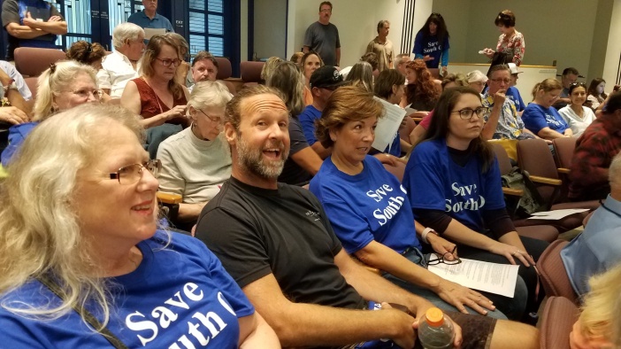
In response to public pressure, the hearing was moved from 2pm to 6pm. Fewer South O representatives were able to make it than on June 10, while more supporters of the Road Diet showed up.

Thanks to efforts by our PR advisor, the hearing was filmed by TV cameras (and stories) from Channel 5/69 (KSWB), NBC 7/39 (KNSD) and KUSI 9/51. The Save South O perspective was featured in the KSWB story, as well as a pre-story by KNSD

Council Decision

The Road Diet supporters from Seaside and environmental groups testified in favor of the PC decision, for a Road Diet (with traffic circles) from Morse Street north. South O representatives asked that the Road Diet end at Oceanside Blvd.

A motion to create a Road Diet citywide by Councilman Rodriguez failed for the lack of a second. Then Mayor Weiss made a motion to create an Incentive District from Morse to Seagaze — with a decision on a Road Diet to be postponed until later. Although that motion was seconded by Councilman Keim, it was withdrawn in light of opposition by Rodriguez.

Rodriguez then motioned to approve Alternative 3, seconded by Weiss, and it was approved by a 4-1 motion (Councilwoman Sanchez opposed). Throughout the discussion, Councilman Feller expressed the strongest opposition to the Road Diet.

With the decision, the city will

  • Create an Incentive District from Seagaze south to Morse St.
  • Add crosswalks at Whaley and Kelly in South O
  • Keep the existing Road Diet for the half mile from Morse to Oceanside Blvd
  • Add a new Road Diet for almost 2 miles, north from Oceanside Blvd. north to Harbor Drive.

Traffic Circle-Large

The proposal would also add traffic circles at seven intersections in the Road Diet:

  • Coast Highway & State Route 76
  • Coast Highway & Civic Center Drive
  • Coast Highway & Pier View Way
  • Coast Highway & Washington Avenue
  • Coast Highway & Wisconsin Avenue
  • Coast Highway & Michigan Avenue
  • Coast Highway & West Street

Intersections at Mission and Oceanside Blvd. will remain signals, because (according to the city’s studies) they have too much traffic for a traffic circle.

This is a great improvement since Save South O began organizing opposition nearly three years ago, even if it leaves the Road Diet in place in the “Dip” between Morse and Oceanside Blvd.

Potential Changes

The council also approved (4-1) a second motion by Keim — to study removing the Road Diet from the Dip. (The three Environmental Impact Reports never studied this option, which was the one repeatedly requested by South O representatives).

The staff was directed to study the impacts of Alternative 3 but with no Road Diet south of Oceanside Blvd. After that study is completed, the council would then vote whether to adopt this approach, or keep this week’s plan (Alternative 3) unmodified.

This was an encouraging outcome, but South O residents and merchants will need to voice their support for this option once it returns to the council. Save South O will keep everyone posted.

The KEY Coast Highway vote

On Wednesday (Aug. 14), the City Council will finally vote on the Coast Highway plan. The proposal, developed since 2007, has two major elements: the Road Diet (cutting 4 lanes to 2, replacing signals with traffic circles) and an Incentive District for developing on Coast (both denser development and accelerated approval).

The hearing was originally planned for 2pm, but — in response to public complaints — the council last week voted to move the hearing to 6pm; it is the only agenda item. It will be held at the council chambers, on the 2nd floor of 300 N. Coast Highway.

Save South O summarized its position and arguments in a June posting. As South O residents have asked for the past three years, we call for no Road Diet anywhere in South O — i.e. 4 lanes south of Oceanside Blvd. We also the city to reject plans for any Incentive District South of Morse Street. This position was unanimously backed by the South Oceanside Business District.

While many in South O oppose any Road Diet, the June 10 Planning Commission hearing made clear that many residents downtown (aka Seaside, aka Townsite) support the Road Diet. Thus, South O asked the Planning Commission respect our wishes and recognize that South O is not downtown.  South O does not want a road diet: 23 from South O testified against a South O Road Diet, while 2 testified in favor.

The Planning Commission voted to endorse Alternative 3: no Road Diet or Incentive District south of Morse Street. In addition, this option provides South O with two new protected crosswalks; as the April 2019 Final EIR (Volume 1, p. S-8) writes:

Alternative 3 would provide Class III sharrow markings on Coast Highway between Morse Street and Vista Way and curb-extending mid-block pedestrian crosswalks at Whaley Street and Kelly Street.

Eliminating the South O Road Diet

The “temporary” road diet — begun in March 2016 — has now run to 40 months. On weekends — and much of the summer — it has brought regular gridlock as residents, employees and visitors struggle to get in and out of South O from its main northern entrance.

There are many reasons to oppose the Road Diet South of Oceanside Blvd. — including that Coast is part of the city’s official tsunami evacuation route. However, there is an inherent contradiction in Alternative 3 — which increases density in the Dip while reducing traffic lanes.

In the city’s Incentive District plan, any property marked as a “Node” (purple) is allowed to be 65′ maximum height (55′ average height) and 63 dwelling units/acre.

Map-SprinterNode
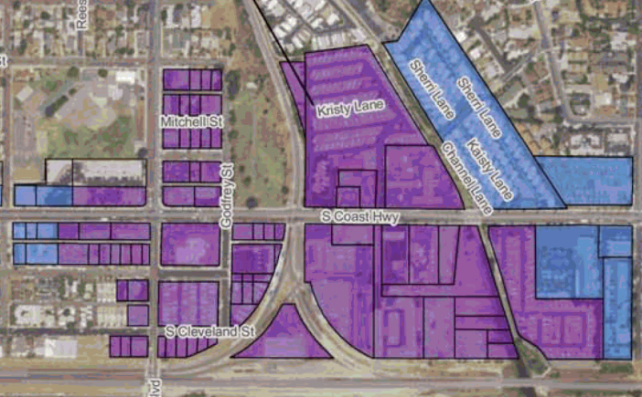
Public records show that the Node properties around the Sprinter station total 38.69 acres. This would allow 2,437 new dwelling units — in addition to any residential development in the (blue) “Avenue” properties, which allow all-residential projects up to 45’ high.

Worse, 15.39 acres of Node properties are South of Godfrey Street. There is no way for residents of these properties (and the associated 970 units) to drive to their property without either driving in (on the East side) or driving out (on the West side) via South Oceanside.

Some claim that these residents will not have cars, but instead will use mass transit. However, cars will be important for these residents for at least several decades. The Sprinter has had only limited ridership to date, averaging 46,000/week across the entire system in the most recent fiscal year.

In addition, like other brand-new units West of I-5, these units will rent for $2,000-3,000/month, which under federal guidelines means they’ll need a household income of $80k-$120k/year; buying a $600,000 condo would also require about $120k/year. This is more than what two people making $15/hour can afford, and well above the average Oceanside household income (which is $62k/year). Clearly many of these affluent renters/owners will have cars.

Taking Action

Save South O was formed to make the concerns of South Oceanside heard at City Hall. In turn, we need your help. We ask that you please

  • Email the council to voice your opposition to any Road Diet south of Oceanside Blvd.
  • Come to the hearing at 6pm Wednesday:
    • Wear your “Save South O” t-shirt if you have one (contact us to obtain one); if you don’t have one, please wear a blue shirt
    • Be polite at all times
    • When you testify, ask the council that in addition to Alternative 3, that the “Dip” be restored to four lanes, i.e. no Road Diet between Oceanside Blvd. and Morse Street.

Coast Highway Victory

On Monday night, more than 50 South O residents turned out for the first Coast Highway hearing of 2019. We got most of what we wanted, marking a dramatic turnaround from where we started in Fall 2016.

The Hearing

After discussion of two long (Coast Highway) commercial projects, the Coast Highway hearing started at 7:20pm and didn’t end until around 11. It began with staff reports, more than 40 people testifying, and then discussion by six of the seven PC members (one recused herself). Reporters from the SD Union and SD Reader stayed until the end.

The main tension was between Road Diet supporters and opponents of the Road Diet from South O; the latter outnumbered the former by about 2:1. We had more than 40 supporters wearing Save South O t-shirts (of the 80 we distributed in the past week), and probably about 60 overall.

i0000010-3
About one third of the Save South O t-shirts at the hearing.

The Arguments

There was nearly 2 hours of testimony (at 2 minutes each). The chair of the PC, Kyle Krahel, kept score, and counted: 23 South O against a South O road diet, 14 in favor of a road diet citywide, and 4 opposed to a road diet citywide.

Supporters. Among the speakers favoring implementing the Coast Highway plan citywide, four were affiliated with the bike coalition and one spoke on behalf of the Sierra Club. One South O resident testified in favor of the road diet, but in general it seemed as though if you like the idea of the road diet, you’ve already chosen to live in Seaside — east of Coast, between Oceanside Blvd. and Mission.

In general, those testifying for the Coast Highway Vision supported the road diet, bike lanes, and the increased residential housing density. A few pointedly said they wanted it for the whole city, including South O. Many accused their opponents of being ignorant, or fearful of change.

Opponents. Based on a decision made by SSO leaders in 2017, the position of Save South O and most of its supporters was we don’t seek to dictate what happens downtown, but conversely want our wishes to be respected in South O. Speaker after speakers said that the road diet and the incentive district don’t belong in South O, making arguments familiar to readers of this blog. The speakers criticized the plan — and sometimes the process — but not our fellow citizens.

Of the 24 South O speakers, eight represented South O businesses, including six from the South Oceanside Business District: the president, vice president, and four other founding members.

The general theme was that the businesses had taken financial risks, the economy was developing nicely, and we neither needed the incentives nor wanted to disruption to our traffic mobility. They also talked about how one of the high density “nodes” — tied to the Cassidy Street freeway onramp rather than any bus lines — would demolish the buildings occupied by Privateer Coal Fire Pizza and Anita’s Mexican Restaurant.

i0000010-6
South O business owners prepare to testify against the road diet

Earlier in the day, Save South O was featured for 10 minutes on the John and Ken show on KFI AM 640. They have been very skeptical of road diets, particularly the five in Los Angeles County.

Vote

After the end of testimony, the PC members asked questions of staff and then deliberated. The PC briefly considered stopping at Oceanside Blvd. — what Save South O and the community requested this week, and what we have repeatedly insisted on for more than two years.

Instead, the PC voted unanimously to recommend Alternative 3:

  • no road diet south of Morse; continue the existing road diet in the “Dip”
  • no incentive district south of Morse, but have high density “Node” residential (up to 63 units/acre) for most of Coast from Oceanside Blvd. to La Salina Creek

Save South O is evaluating its next steps. In the light of our strong turnout and the PC support, it appears that the city is willing to work with us to address some of our concerns, so we want to see if there is common ground.

Thanks to all who turned out to support us Monday! And we hope to see many of you Wednesday at 2pm.

Road Diet nightmare

Monday night (6pm) is the Planning Commission hearing on the Coast Highway Corridor plan. (Wednesday 2pm is the Council hearing to enact the Short-Term Rental Ordinance).

The Coast Highway plan includes two part: the Incentive District and the Road Diet. The Incentive District would provide density and a look in South O that would make it more like downtown. South O is not downtown: it has been an economic success without such a plan, and local business owners would like to keep it that way.

The Road Diet Nightmare

The Road Diet would shrink Coast from 4 lanes to 2. South O lacks and will continue to lack the transit density of downtown, and thus for decade it will continue to be dependent on automobiles — whether electric, hybrid, fuel cell, natural gas or gasoline — and whether self-driving, shared or private.

Whatever its merits for downtown, here are 5 reasons what the road diet would be a disaster for South O:

  1. Traffic Nightmares. As the “pilot project” road diet has shown, eliminating half the traffic lanes in South O will bring traffic to a standstill at rush hour and summer weekend months, making it difficult for residents and visitors to enter and exit our community and diverting traffic onto side streets of South O residential neighborhoods. According to the city’s data, a full road diet will only make it worse.
  2. Against Federal Guidelines. In 2014, the Federal Highway Administration published a Road Diet Information Guide. The existing — let alone projected — traffic levels exceed the range that the FHWA says is “probably feasible” for a road diet.
  3. Consistent Resident Opposition. The residents of South O have consistently voted to oppose having a road diet south of Oceanside Blvd — including the 400 petition signatures of Oceanside residents that we presented to the council in October 2016 (attached), and more than 70 people who turned out to oppose it at a community meeting held January 3.
  4. Safety and Emergency Access. Coast Highway is a major ingress/egress route for all of South O, including for tsunami evacuation from the lagoon and from the “Dip”. The importance of such emergency access will only increase if Caltrans closes (as it is threatening to do) the Cassidy Street onramps and offramps.
  5. Economic Impact. The city’s EIR fails to examine the economic impact of the Road Diet on the South O merchants, who depend on auto-based visitors for their livelihood. A similar Road Diet on Venice Blvd. in Los Angeles brought the closing of 15 businesses. The Board of Directors of the South Oceanside Business District has voted unanimously to oppose any Road Diet South of Oceanside Blvd.

Because of this, as we have done consistently over the last three years, Save South O and the residents of South Oceanside ask for no road diet South of Oceanside Blvd.

City Segment 5A

Moving Forward

Over the past 30 years, South O has been redeveloped with private risk taking and private investment to make our community a unique attraction within Oceanside and North County. We are not downtown — we lack the infrastructure and other attractions that have been used to justify the Coast Highway Vision north of Wisconsin.

If (we hope when) this plan is rejected for South O, the residents and merchants of South Oceanside — organized by the South Oceanside Business District and Save South O — intend to continue to work with the city to develop improvements suitable for our community. This includes completing the rail trail, adding suitable pedestrian crosswalks, and beautifying storefronts.

Unlike downtown, South Oceanside residents and merchants are strongly opposed to this plan — as we have been for the past three years. The latest staff proposal ignores both our repeated substantive input and also the community wishes in continuing to threaten our community with these drastic (and inappropriate) changes.

We ask the Planning Commission to either reject the Coast Highway plan, or to approve an option that

  • does not include any Road Diet south of Oceanside Blvd.;
  • modifies the incentive district in consultation with South O between Oceanside and Morse prior to the Council vote; and
  • deletes any incentive district south of Morse.

A ‘Road Diet’ Fad Is Proving to Be Deadly

From the Wall Street Journal op-ed section, January 19, 2019:

Vision Zero, a ‘Road Diet’ Fad, Is Proving to Be Deadly

Emergency vehicles get stuck on streets that have been narrowed to promote walking and bicycling.

By Christopher D. LeGras
Jan. 18, 2019 6:17 p.m. ET
Renee Khoury was in the kitchen when she heard a scream. She ran outside and found her 65-year-old mother, Rebecca, sprawled on the sidewalk with a compound fracture in her left leg. Renee called 911 then comforted her mom as best she could.The Khourys live five blocks from Fire Station 62 in West Los Angeles’s Mar Vista neighborhood. They heard a siren right away, but something was wrong. It wasn’t moving. “It took 10 minutes,” says Renee’s husband, Jeff. “Becky was in pain. They could hear help but it couldn’t reach them.”

Los Angeles, like cities nationwide, is transforming its streets. In July 2017 the city installed a “road diet” on a 0.8-mile stretch of Venice Boulevard in Mar Vista, reducing four lanes to two and adding bike lanes separated from traffic by parking buffers. The project is part of Mayor Eric Garcetti’s Vision Zero initiative, which aims to eliminate traffic fatalities in the city by 2025. Launched in 2015, Vision Zero is the most radical transformation of how people move through Los Angeles since the dawn of the freeway era 75 years ago.

By almost any metric it’s been a disaster. Pedestrian deaths have nearly doubled, from 74 in 2015 to 135 in 2017, the last year for which data are available. After years of improvement, Los Angeles again has the world’s worst traffic, according to the transportation research firm Inrix. Miles of vehicles idling in gridlock have reduced air quality to 1980s levels.

The international Vision Zero movement began in the 1990s in Sweden, where it apparently worked well. The Swedish government claims a 50% reduction in traffic deaths since 2000. Hoping to achieve similar gains, U.S. mayors from New York City to North Pole, Alaska, have adopted Vision Zero. Projects range from multibillion-dollar light-rail lines to retiming traffic lights for slower traffic. Road diets are key.

In neighborhoods across New York City, residents, community boards and local businesses have done battle with city officials over “traffic calming” measures imposed by city hall. Lane reductions, bike lanes, new meridians and other innovations designed to reduce vehicle speeds make it difficult for bulky ambulances and fire trucks to respond quickly to emergencies. And while pedestrian deaths have plummeted in the Big Apple under Vision Zero, deaths of bicyclists, motorcyclists and people in vehicles have ticked up.

Around the country, officials have implemented projects on short notice, over local objections and without consulting first responders. Howard Holt, a fire captain in Oakland, Calif., said he found out about a road diet in front of his station when he arrived for a shift one morning. “I wasn’t sure if I was supposed to drive in the new green lanes,” he said recently. “Turns out they’re bike lanes.” He calls the city bureaucracy “The Wall.”

During the 2017 La Tuna Fire, the biggest in Los Angeles in half a century, a road diet on Foothill Boulevard the in Sunland-Tujunga neighborhood bottlenecked evacuations. After the fire a neighborhood association voted to go off the road diet. The city ignored the request and instead added another one to La Tuna Canyon Road.

The story isn’t confined to big cities. In Waverly, Iowa (pop. 9,837), Fire Chief Dennis Happel and Bremer County Sheriff Dan Pickett say the city has ignored their concerns over a road diet plan. In Fairbanks, Alaska, Fire Battalion Chief Brian Davis says the city installed traffic controls to mitigate the impact of new bike lanes in front of his fire house. In January the average high temperature in Fairbanks is zero Fahrenheit—much too cold to ride a bike.

It’s noble to want to make America’s streets as safe as they can be. But government officials shouldn’t impose projects on communities that don’t work, inconvenience residents, hurt businesses and impede emergency responders in the process.

Mr. LeGras is an attorney and writer in Los Angeles.

Appeared in the January 19, 2019, print edition.


Why a Road Diet won’t work in South O

The city is nearing a  final decision about the “Road Diet”, its proposal to shrink some or all of Coast Highway from 4 lanes to 2 lanes. This is a project that’s been discussed and studied for more than a decade.

Traffic Circle-Large
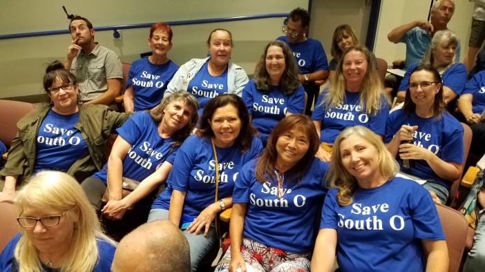
Today the city is considering four Alternatives (see here), all of which include a Road Diet with roundabouts. Alternatives 1-3 also include development incentives that could increase residential units 9x and hotel rooms 7x. In July 2017, the city issued a 2,309 page Environmental Impact Report studying Alternatives 1,2,4. In November 2018, it issued a 2,406 page supplemental EIR that studied its new Alternative 3; feedback on the 2018 EIR is due by January 14.

However, neither of the city’s EIRs acknowledge the official “Road Diet” guidance of the Federal Highway Administration (FHWA), as reflected by its November 2014 Road Diet Information Guide. The guide has been available on their website since then, but it is not mentioned in either EIR. According to the Federal guidelines, the existing (and future) traffic levels on Coast Highway are too great for a Road Diet to work here.

What the Guide Says

After reviewing the history of Road Diets over the past 40 years, the FHWA guide talks about the reasons for a diet (Ch. 2), whether a local context is suitable (Ch. 3), how to design a diet (ch. 4) and to measure its success (ch. 5). Only 3 paragraphs of the 72 pages discuss roundabouts; one paragraph recommends against introducing a road diet with roundabouts at the same time due to potential public opposition.

Section 3.3 talks about the operational factors that make a diet suitable or not suitable, based on vehicles per day (VPD) and vehicles per hour per day (VPHPD):

3.3.5 Average Daily Traffic (ADT)

The ADT provides a good first approximation on whether or not to consider a Road Diet conversion. If the ADT is near the upper limits of the study volumes, practitioners should conduct further analysis to determine its operational feasibility. … The FHWA advises that roadways with ADT of 20,000 vpd or less may be good candidates for a Road Diet and should be evaluated for feasibility.

3.3.6 Peak Hour and Peak Direction

The peak hour volume in the peak direction will be the measure of volume driving the analysis and can determine whether the Road Diet can be feasibly implemented. …The Iowa guidelines suggest, from an operational point of view, the following volume-based Road Diet feasibility conclusions (assuming a 50/50 directional split and 10 percent of the ADT during the peak hour):

  • Probably feasible at or below 750 vehicles per hour per direction (vphpd) during the peak hour.
  • Consider cautiously between 750 – 875 vphpd during the peak hour.
  • Feasibility less likely above 875 vphpd during the peak hour and expect reduced arterial LOS during the peak period.

Finally, the guide also says that “Road Diets can cause some diversion of traffic to parallel routes.” In the original EIR, South O and Seaside residents both complained to the city that the Road Diet would cause frustrated drivers to leave Coast for streets paralleling Coast. The 750 vphpd standard means 1,500 vehicles/hour in both directons.

How This Applies to Oceanside

How does this apply to Oceanside? If you look at the November 2018 EIR, Coast Highway peak evening traffic is already above the FHWA’s peak recommended level for Oceanside Blvd. and points south.

Road Diet none to Oside Blvd to Morse to Morse
Incentives none all Coast all Coast to Morse
Year 2013 2035 2035 2035
Alternative Existing Alt. 1 Alt. 2 Alt. 3
Harbor & Coast 579 704 704 579
Mission & Coast 1,047 1,845 1,845 1,047
Wisconsin & Coast 1,379 1,422 1,422 1,379
Oceanside & Coast 1,638 1,570 1,570 1,638
Morse & Coast 1,510 1,847 1,847 1,510
Cassidy & Coast 1,572 1,646 1,646 1,572
Vista Way & Coast 1,664 1,947 1,947 1,664


Economic impact of the “Road Diet”

The city’s proposed “Road Diet” proposes eliminating half of the trafic lanes lanes on Coast Highway, reducing Coast from 4 lanes to 2 from Oceanside Blvd. north to the Harbor. Of the four options, two options (Alternative 2,3) also narrow traffic lanes south to Morse Street, and one (Alternative 4) cuts it citywide, including all of South O.

Local businesses fear that the reduced access will put them out of business. However, the city has not released the data from its test “Road Diet”, nor does its latest EIR talk about the potential economic impacts of the road diet. (Comments on this EIR are due by 5pm January 14).

The 33 Month Pilot Study

For nearly three years — since March 31, 2016 — the city has experimented with a “temporary” road diet on Coast between Morse and Oceanside. At the time, city staff said the data would support the city’s proposed road diet citywide:

“I hopes this will prove we can do a two lane Coast Highway,” David DiPierro, city traffic engineer, said. “The public can see what a two lane Coast Highway would look like. If it does not work, as we intend it to work, we can revert back and study it more.”

When the “pilot program” was approved, the city said

[Scott] Smith said part of the pilot design would track changes in vehicles speeds and traffic patterns, including use of side streets.

A Traffic Measurement System would be installed in the study area between Oceanside Boulevard and Morse Street to measure vehicle travel time, speed and origin of destination. This would allow analysis of road changes on drivers’ commute times.

While the city has gathered the data, no report has been issued to the public. Individual council members have said they also have not received the data.

However, residents have experienced increased traffic congestion on this stretch between Oceanside and Morse, with traffic jams common on weekday afternoons and summer weekends. The city is aware of these effects.

coast-before
Coast Highway crossing Loma Alta Creek, before pilot project (Source: Bing Maps).
coast-after
Coast Highway crossing Loma Alta Creek, during pilot project (Source: Google Maps).

Studying Economic Impacts

When it comes to economic impacts, the November 2017 EIR only talks about the historic impacts of the Coast Highway, not the impact of the proposed changes. This phrase appears three times:

From the early to mid-20th century the Coast Highway was a major economic driver in the City of Oceanside and was largely responsible for the City’s growth from the 1920s through the 1950s.

Under the CEQA guidelines (14 CCR § 15131b in the California Code of Regulations) says

Economic or social effects of a project may be used to determine the significance of physical changes caused by the project. … Where an EIR uses economic or social effects to determine that a physical change is significant, the EIR shall explain the reason for determining that the effect is significant.

The discussion of economic impacts in the July 2017 EIR mainly focuses on the temporary disruption due to construction. However, it does say the proposal is consistent with the county’s strategy for increased residential density and reliance on alternative transit as a path towards “reduced congestion”:

Sustainable Communities Strategies

In October 2015 the San Diego Association of Governments (SANDAG) adopted the 2015 Sustainable Communities Strategies (SCS), which builds on the previous 2011 SCS and directs investments within existing urbanized areas to encourage growth within existing higher-density urban boundaries and discourages urban and suburban sprawl. Elements of the 2015 SCS that have been implemented include the completion of bicycle and pedestrian projects and the expansion of transit with new rapid bus service. The goals of the 2015 SCS include increasing the number of homes and jobs near transit, reducing transit travel time, and achieving economic benefits due to reduced congestion and the construction of transportation infrastructure, as well as reducing air pollutant emissions.

Potential Impacts

At the January 3 meeting hosted by Save South O, local businesses (particularly those in the dip) complained about the disruption of the existing (temporary) road diet, as well as the greater harm of reducing lanes and increasing density, potentially citywide.

The fear of negative impact on local businesses is real. In the eight months of the “road diet” on Venice Blvd. in Los Angeles, 15 businesses have closed their doors. The remaining businesses are struggling with angry and frustrated customers.

With only about 50 businesses in South O along Coast Highway, losing 15 businesses here would be very damaging both to the community and to business confidence in Oceanside more generally.

A clear message from South O

More than 70 people turned out this evening for Save South O’s community workshop about the Coast Highway EIR. Those attending heard about

  • The history of the Coast Highway Vision process that began in 2007
  • How the city’s process seemed geared towards generating a specific result (the road diet), rather than listening to what the community wanted
  • The differences between the five proposed alternatives as they would impact South O
  • The negative impacts of the proposed road diet and development incentives on South O — including (with some options) more traffic from increased density with fewer traffic lanes
  • The impact the “temporary” road diet between Morse and Oceanside Blvd. has already had on merchants there
  • The potential for the traffic circles (not normally used on such narrow streets) to slow emergency vehicle access, and resident concerns about their negative impact on pedestrian safety
  • The strong and consistent opposition of South O residents and business owners to the proposed changes
  • The plans of the South Oceanside Business District to push for lighted crosswalks across Coast Highway, particularly at Kelly and Whaley, and better speed enforcement on Coast
  • The better bicycle safety provided by completing the Rail Trail (or having cyclists continue to use Pacific Street)
img_7519-cropped
Charlie Anderson addresses the Save South O meeting at Beach Break Cafe, January 3, 2019

Those present also heard about the positive vision that South O leaders have to maintain and (incrementally) improve the character of the community, a process that has been going on without (or despite) city hall intervention. As Charlie Anderson said, we want to keep South O “authentic”, which will keep Oceanside attractive to both locals and out of town visitors.

We met at Beach Break Cafe, founded 30 years ago in South O and now the anchor of the business district. Co-owner Zell Dwelley talked about how they invested first to create the business, and then to move to their current, much larger location in 2010 — without developer incentives. It is this sort of organic, community-driven growth that we believe will preserve the character of South O that drew us all to this unique North County neighorhood.

Our Recommendation

For all the reasons summarized (and linked) above, Save South O believes what is best for South Oceanside is for city to keep the Road Diet and Development Incentives north of Oceanside Blvd., with no Coast Highway changes south of Oceanside Blvd.

Despite the community’s consistent position, the council did not study this option in their EIR; instead, the options are:

  • No Project Alternative: no change from today
  • Alternative 1, Road Diet on Coast Highway from Harbor Drive to Oceanside Blvd., and development incentives throughout the city, including South O
  • Alternative 2, the same as #1 except it extends the Road Diet to Morse (through the “Dip”), with the Incentive District throughout the city
  • Alternative 3, Road Diet and Incentive District from Harbor Drive to Morse Street
  • Alternative 4, a Road Diet for the entire city, with no development incentives

Therefore, the only two options we can recommend are

  • No Project Alternative: the only option the city studied that leaves South O alone
  • Alternative 1, but modified with no Development Incentives south of Oceanside Blvd.

Note that Save South O takes no position on what happens north of Oceanside Blvd. For the same reason that we believe South O deserve autonomy for what happens here, we hope the council decision will reflect the will of the majority of the impacted residents and businesses in North coastal Oceanside.

Submitting Feedback

After issuing the revised EIR in November 2018, the city has set a deadline for submitting feedback: 5 p.m. Monday January 14. Feedback should be sent to John Amberson (JAmberson@ci.oceanside.ca.us). Residents may also want to send their feedback to the city council at Council@ci.oceanside.ca.us

Given our clear arguments, several outside visitors — as well as newcomers to South — said they found it hard to imagine why the city would oppose this position. At this point, our biggest enemy is complacency.

We encourage all South O residents to contact both city staff and the council to let them know your position. You should not only state your position, but also any specific aspect on your, your family or your business that the proposed changes might have.

Please also contact your friends and neighbors — not only those who live in South O, but anyone else who lives in the city who shares your concerns. A change to the character of South O will impact those who visit our community as well.

Feel free to contact Save South O if you have any questions or concerns.

Comparing the Coast Highway options

At Thursday’s meeting, Save South O will host an event discussing the impact of the city’s five Coast Highway alternatives upon Oceanside south of Oceanside Blvd., in advance of the January 14 feedback deadline.

Alternatives Being Considered

  • No Project Alternative, which would be no change from today
  • Alternative 1, puts the Road Diet on Coast Highway (cutting 4 lanes to 2 lanes) from Harbor Drive to Oceanside Blvd., and development incentives throughout the city, including South O.
  • Alternative 2, the same as #1 except it extends the Road Diet to Morse (through the “Dip”), with the Incentive District throughout the city.
  • Alternative 3, Road Diet and Incentive District from Harbor Drive to Morse Street.
  • Alternative 4 (former Alternative 3), a Road Diet for the entire city, with no development incentives.

These alternatives are summarized in this table:

No Proj Alt 1 Alt 2 Alt 3 Alt 4
Road Diet
Harbor-Oside Blvd no (4 lanes) YES (2 lanes) YES (2 lanes) YES (2 lanes) YES (2 lanes)
Oside Blvd-Morse no (4 lanes) no (4 lanes) YES (2 lanes) YES (2 lanes) YES (2 lanes)
Morse-Vista Way no (4 lanes) no (4 lanes) no (4 lanes) no (4 lanes) YES (2 lanes)
Density increases
Harbor-Oside Blvd YES YES YES
Oside Blvd-Morse YES YES YES
Morse-Vista Way YES YES

Road Diet

Traffic Circle-Large
The proposed “road diet” for Coast Highway has two major elements:

  • Reducing the traffic lanes from four lanes to two
  • Replace various traffic lights and unprotected intersections with traffic circles (rotaries)

Two years ago, with their concern about increased traffic congestion and reduced access to South O, more than 400 Oceanside residents petitioned against having the road diet in South Oceanside (as later reported by Union-Tribune and Coast News and San Diego Union-Tribune).

Development Incentives

Map-SouthO A major aspect of the Coast Highway plan is creating a “Development Incentive Overlay”.  The major aspects of these incentives are:

  • Increased residential density for mixed use projects, up to 63 units/acre
  • Increased heights (up to 55′ average or 65′ maximum height)
  • Little or no public input (e.g. Planning Commission hearings) for many applications

This highest density development (63 units/acre, 55-65′ max) is known as a “Node” in the city’s parlance and is shown in purple in the map above. It would be found in two places in South O:

  • The Sprinter Node, including all land between Loma Alta and Oceanside Blvd., plus Paradise-by-the-Sea.
  • The northeast corner of Cassidy — the former Blade-Tribune (North County Times) block. Any redevelopment of this block would affect several existing businesses: Anita’s, Bob’s Gas, Central Autobody, Privateer, and Raen.

Bicycle Safety

The Road Diet envisions painting a stripe along Coast Highway to reserve the right lane for bicycles. Save South O believes that rather than a Class II bike lane on Coast Highway — next to heavy traffic and with the risk of accidents from cars entering from driveways and side streets — a safer (and for almost all cyclists, faster) option is to finish the Class I (dedicated right-of-way) bike path, the Coastal Rail Trail.

What remains to be done is completing a bridge across Loma Alta Creek. Last June, city received a $400k SANDAG grant for planning this crossing:

The first grant, Environmental Study for the Coastal Rail Trail across Loma Alta Creek  … would extend the existing Coastal Rail Trail limits in the City of Oceanside by creating a Class I bicycle and pedestrian path that spans across the Loma Alta Creek between Oceanside Boulevard and Morse Street. This connection would improve pedestrian and bicycle mobility and create a relatively safe route for pedestrians and bicyclists between North and South Oceanside.

Meeting Info

The meeting will be Thursday, January 3, at 6pm, at Beach Break Cafe, 1802 S Coast Highway (cross street Cassidy).

Providing Feedback

After issuing the revised EIR in November 2018, the city has set a deadline for submitting feedback: 5 p.m. Monday January 14. Feedback should be sent to John Amberson (JAmberson@ci.oceanside.ca.us). Residents may also want to send their feedback to the city council at Council@ci.oceanside.ca.us

Activists score partial victory against LA road diet

Some of the impetus for the Coast Highway “road diet” comes from the state of California which, with SB 743 and other measures, is trying to coerce local governments into making it harder to use automobiles in the name of reducing greenhouse gas emissions.

LA’s War on Cars

One city that has gone above and beyond the state mandate in its war on cars is the City of Los Angeles, including imposing its own road diet in at least 40 roads across the city. The first area affected was the Playa del Rey neighborhood north of LAX, which suffered rush hour gridlock after the diet was implemented earlier in June.

In response to the Playa del Rey road diet, local residents filed two lawsuits. One by members of a condo association citing potential delays for emergency responders. Another lawsuit, by a new community group, “Keep LA Moving”, cited the increased traffic congestion, reduced access to beaches and homes, loss of revenue for local businesses and an increase in accidents.

Last week, city officials reversed themselves and agreed to undo the diet on four streets. Instead, the city will add flashing beacon crosswalks and other less drastic traffic calming measures. On YouTube, local activists describe their successful efforts.

The decision came as residents prepare to gather signatures to initiate an election to recall Mike Bonin, the L.A. councilman who led the road diet efforts.

Implications for Oceanside

There are several implications for South O residents. First and foremost, it shows that organized citizen action can make a difference and get the attention of city hall, even in a city of 3.8 million (let alone one 20x smaller like Oceanside).

Second, it points out the illogic of the state’s contradictory policies that on the one hand seek to shift California from internal combustion to Zero Emission Vehicles — while making it harder for taxpayers to use those vehicles. Highly urbanized job centers like San Francisco and downtown L.A. may be accessible via mass transit, but most of the state was built out in the last 70 years for the majority of residents in suburban and rural portions of the state.

As the Oceanside’s population continues to grow, Save South O will continue to push to make sure the city provides adequate roads and parking for new and existing Oceansiders — who like so much of the state — depend on their cars to get to work, school, shopping and other destinations.