Massive condo project at PC Monday

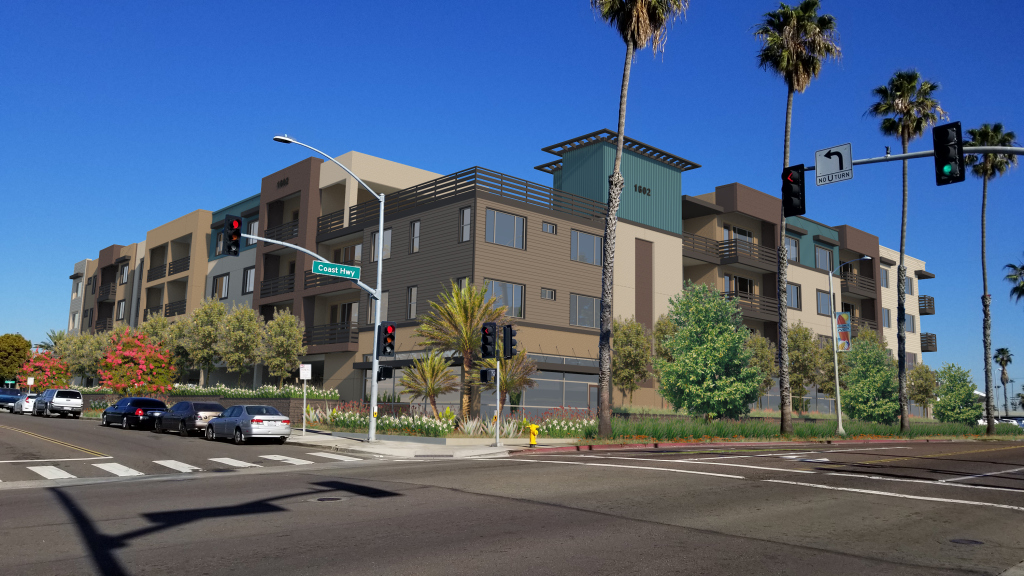
For almost five months, South O residents have been fighting plans for a massive (and unprecedented) condo project at 1602 S. Coast (SE corner of Morse and Coast). It comes before the Planning Commission Monday at 6pm: the public can participate in person, via zoom, phone or emailed comments.

This project has unprecedented scale and density for any South O development on Coast Highway. If the Planning Commission follows the staff recommendation, this project will set a precedent to change permanently change the character of South O.

Summary

The staff report is recommending approval of the 54 unit project at the SE corner of Morse and Coast Highway. The report says that the developer, Hallmark Development of Solana Beach, held outreach meetings with the community, which it did (via Zoom) on April 14 and May 4.

What it doesn’t say is that the developer made no substantive changes to the areas where South O residents fiercely objected: height, scale, density and inadequate parking.

Unprecedented Height

The staff report claims

This proposed development would be compatible with surrounding developments in terms of land use, density, and lot size. The proposed four (4) story mixed use development is consistent with many of the existing and proposed mixed~use developments along South Coast Highway. The existing developments within the neighborhood range from one to two-story single-family and two to three story multi-family complexes, commercial and office developments.

In other words, a new 4 story, 42′ tall condo project is “compatible” with the neighborhood.

  • Of all the commercial development on Coast Highway from Morse Street to the city limits, there is exactly one building taller than two stories: the portions of the abandoned Blade-Tribune building near Cassidy St. So there is no precedent for a 4-story, 42′ building.
  • The residential development east of Coast between Morse and Cassidy is 1- and 2-story single family homes and apartments. The proposed project will dwarf and shadow this neighborhood unlike any others.

Unprecedented Density

The report says the Morse Street Townhomes (north of Morse, east of Coast) sets a precedent for this project.

The Morse Street Townhome project located directly north from the project site along Morse Street was recently developed as a three-story condominium project and is similar in terms of density, scale, and architectural features

However, a cursory comparison of these two projects shows that the new project has unprecedented density (more than 3x as large) and scale (both in terms of height and lot coverage):

Morse Street Townhome1602 S. Coast
Area2.3 ac0.9 ac
Height34.5′42.0′
Stories3 plus roof deck4 plus possible deck
Units3854
Density16.5 du/ac59 du/ac
Commercial03,300 sq ft
Parking83 spaces77 spaces
Lot coverage33%86%

The report also claims that “the proposed development … is consistent with the goals of the Coast Highway Corridor Study and Coast Highway Vision and Strategic Plan.”

However, the use of a project north of Morse is a red herring. The staff knows full well that while the 2007 Coast Highway Vision called for increased density along Coast, when the council voted in August 2019 to enact that vision, it voted to eliminate density and development incentives from all property south of Morse Street. So city development policy North of Morse is different from that South of Morse. (Just as development policy West of Coast is different from that East of Coast).

Inadequate Parking

The project has 34 2BR units, 20 3BR units and 64 residential parking spaces. In addition it has 11 spaces for commercial use and 2 guest parking spaces.

According to the April 14 community meeting, developer is expecting to sell these condos for $600-800k. However, it is claiming that the residents won’t own as many cars as elsewhere in the city, because it is 0.4 miles from the Sprinter station at Godfrey Street. Given people buying these condos will (under HUD guidelines) need a household income of $60,000-80,000/year, any survey or study of homeowners in Coastal Oceanside would suggest that (as with other SoCal suburbs) most residents will have one car per adult.

One thing that the Morse Townhomes have shown: inadequate parking in the residential project (which makes the project more profitable for the developer) will flood local streets with the overflow. This was the single greatest objection by residents at the May 4 community meeting.

Even if residents will learn how to use mass transit, AirBNB visitors from other cities are unlikely to do so. (Neighbors of Short-Term Rentals will also tell you that visitors to such properties often cram as many people with as many cars as possible.) The city and the developer refused to add a deed restriction banning STR rentals at this under-parked property.

How to Participate

If approved, this project will set a precedent for all future Coast Highway redevelopment. You can participate in the hearing:

  • In person: Council Chambers (2nd floor), 300 N. Coast Highway, Oceanside
  • Via the Internet: https://zoom.us/ ; to join, click “Join a Meeting” at the top of the Zoom webpage. Enter the Zoom Meeting ID: 881 1127 3720
  • Via telephone: (669) 900-6833, and then enter the meeting ID. (Mute your phone unless you are called on)

To comment via

Staff Report: “Land Use Compatibility”

A. Land Use Element
Goal 1.12 Land Use Compatibility
Objective: To minimize conflicts with adjacent or related uses.
Policy B: The use of land shall not create negative visual impacts to surrounding land uses.
The proposed mixed~use development would create a 54 unit residential condominium units and 3,244 square feet of ground floor commercial space and would implement the goals and objectives specified in the General Plan and be in compliance with the State Density Bonus goals of maximizing density. The project meets all required development standards of the C~21CZ zoning district, with the exception of the two (2) requested waivers of the aforementioned development standards as permitted under State Density Bonus Law. This proposed development would be compatible with surrounding developments in terms of land use, density, and lot size. The proposed four (4) story mixed use development is consistent with many of the existing and proposed mixed~use developments along South Coast Highway. The existing developments within the neighborhood range from one to two-story single-family and two to three story multi-family complexes, commercial and office developments. The Morse Street Townhome project located directly north from the project site along Morse Street was recently developed as a three-story condominium project and is similar in terms of density, scale, and architectural features, materials, and enhancements as the proposed development. Given the wide range of aforementioned developments within the area, the proposed development provides an additional eclectic and aesthetic design to the neighborhood and is consistent with the goals of the Coast Highway Corridor Study and Coast Highway Vision and Strategic Plan for development along South Coast Highway.

Participating in Buc and other South O decisions

Here are several key opportunities to South O residents to participate in several key decisions regarding Buccaneer and several other key area of community:

  1. 8:30am July 31: next meeting of Save Oceanside Sand
  2. No later than July 31: Deadline to respond to the City’s official survey regarding the future of Buccaneer Park.
  3. 6:00-7:30pm Aug. 3: initial meeting of Advisory Committee (in Council Chambers or via Zoom) for planning the Beachfront Improvement Project around the Pier.
  4. By 6pm Aug. 6 (South O residents only): deadline for a one-question survey regarding the priorities for community reuse of NCTD land between Cassidy and Morse: either a beach trail or expanded parking.
  5. 2pm Aug. 11: City Council Workshop on Feasibility Study for Beach Sand Replenishment/Retention

Finally, on a lighter note, the 8th Annual South O Car/Boat/Bike Show is being held 9am-3pm Aug. 28 as a fundraiser for South O Elementary. To register or for more information, see http://socalcarculture.com/events.html

Proposed condo project at 1602 S. Coast

At 6:00 p.m. on Tuesday May 4, the South Oceanside Community and Merchants Association and Save South O will be sponsoring an online meeting between the South O community and Hallmark Communities.

The subject is Hallmark’s proposed four-story, 54-unit condominium building at 1602 S. Coast Highway. At the city’s request, Hallmark is meeting with the community prior to an expected Planning Commission hearing this summer.

This is the chance for the community to meet with Hallmark as well as the city planner handling the project.South O residents are strongly encouraged to attend this virtual meeting so that their concerns are addressed prior to Planning Commission consideration of this project this summer

Comparison To Earlier Development

The project is to the south of the the controversial Visa Del Mar (née Morse Street Townhomes, née 514 Morse Street) that was approved in 2015 and finished in 2019. That project brought repeated efforts by South O neighbors to reduce the size and scope of the project.

The new project is taller, higher density, with more units and less overall parking than the earlier Morse Street project. Unlike the earlier project — or the existing usage that is mostly parking lot — the proposed condos have more than 85% lot coverage, meaning that almost every square foot of land is covered with buildings

Vista Del Mar1602 S. Coast
Area2.3 ac0.9 ac
Height34.5′42.0′
Stories3 plus roof deck4 plus possible deck
Units3854
Density16.5 du/ac59 du/ac
Commercial03,300 sq ft
Parking83 spaces77 spaces
Lot coverage33%86%

The higher density, scale and lower parking for the new project have the potential to set a prececedent for transforming the face of Coast Highway in South O.

Compatibility with the Coastal Zone

Under state law, any project in the Coastal Zone must be compatible with the city’s Local Coastal Plan, with requirements that the city:

  • Ensure that all new development is compatible in height, scale, color and form with the surrounding neighborhood.
  • Promote efforts to achieve high quality of design for buildings to be constructed at prominent locations.
  • Use care in remodeling of older buildings in order to enhance rather than weaken the original character of such buildings.
  • Buildings are seen together as a total effect that defines the city/neighborhood. Emphasize this special character further through distinctive landscaping and other features.
  • Recognize natural boundaries of neighborhoods and promote connections/transitions.
  • Preserve notable landmarks and areas of historic, architectural, or aesthetic values and promote the preservation of other buildings and features that provide continuity with past development. Improvement of the neighborhood environment increases personal safety, comfort, pride and promotes further enhancement opportunities.
  • Provide buffering for residential neighborhoods from heavy traffic or other undesirable intrusions when they cannot be avoided otherwise.

Mitigation of Expected Impacts

Previous discussions have already identified major concerns by South O neighbors. For example, the project hopes to take advantage of state reduced parking incentives because it is within a half mile (as the crow flies) from mass transit, i.e. the Coast Highway Sprinter Station. If (as many residents believe) it is dramatically under-parked, the excess demand for parking will spillover onto Morse, Freeman and other nearby streets — reducing the parking available to existing South O residents.

As a minimum, Save South O is recommending the following mitigation measures

IssuePreliminary Recommendation
Traffic: The existing Traffic Study (completed during Covid shutdown) projected 390 trips a day and that 60% would be evenl distributed North/South, 30% East on Morse and 10% south on Freeman.Complete a new traffic study once schools are open (less COVID related closures). Provide small, landscaped median(transition into neighborhood) on Morse and Alvarado to indicate transition to a residential neighborhood and to calmincreased traffic.
Parking: The mix of housing at the project is 54 units for a total of 128 bedrooms including 9 units at 1 bedroom, 34 units at 2 bedroom, 20 units at 3 bedroom and some of the 3-bedroom units also with offices (Zoom Meeting 4/14/21). There are 54 ground level parking spaces of which 11 are electric car charging stations.Provide residents on Alvarado, Morse, California, and Ditmar Streets parking passes to ensure they will have guest/ample parking. Additionally, require the property be deed restricted against short-term-rental use to ensure units in the namedtransit corridor are used for housing.
Architecture and Walkability: The architecture of the building would be an “urban beach design.”Architecture needs more articulation and a softer appearance to achieve the beach look mandated in our Local Coastal Plan. More building articulation will improve and encourage walkability (safety and comfort).

Supporting South O plan for reuse of NCTD land

At Wednesday’s City Council hearing (Item #22), the council will vote formally on a plan developed in the South O community to expand pedestrian, bicycle and car access along NCTD right-of-way.

This is a win-win-win for South O residents. While there has been no controversy so far, South O residents need to email the city council by Tuesday night to make sure it is not derailed by last minute hesitation or objections. (We also expect a few residents will attend the 6pm public hearing). Residents should say they favor the city’s proposed agreement with NCTD to use this land to improve recreation and transportation options for South O residents.

This is tied to NCTD’s ongoing project to reduce fatalities from pedestrians crossing their RR tracks. As part of this, NCTD will add fences on both sides of its tracks between Morse and Eaton, i.e. on ether side of the Cassidy Street RR crossing. This is intended to prevent people from crossing the NCTD tracks, except at the Cassidy crossing and and the underpass at Loma Alta Creek.

Reuse of NCTD Land Near Cassidy Street

The South O proposal modifies the original NCTD plan to move the fences closer to the tracks, to keep some of the existing pedestrian paths, allow for right-angle (or diagonal) parking along Broadway between Morse and Cassidy, and make room for future widening of the Coastal Rail Trail. It also calls for a pedestrian footpath from the end of Morse Street down to the existing Loma Alta Creek bike/pedestrian trail.

As a result of the South O-city-NCTD discussions, NCTD will move some of their fences closer to the tracks to make more land available to South O. Wednesday’s vote is for the city to appropriate $350k in its 2021-2022 capital improvement budget for costs that NCTD will not bear, but must be paid by the city: adding the Broadway parking and creating the pedestrian footpath.

This plan was supported by South O community members at meetings earlier this year, including a January 21 meeting with Deputy City Manager Jonathan Borrego. Save South O and other South O community leaders are pleased by how cooperative both the city and NCTD have been on modifying the original NCTD plans to improve the availability of the land for local residents.

Changes to NCTD land between Morse and Whaley
Changes to NCTD land between Whaley and Cassidy.

Staff Report

Synopsis

Staff recommends that the City Council approve a Memorandum of Understanding and License Agreement with the North County Transit District (NCTD) regarding City use of property owned by the North County Transit District located on the west side of Broadway Street between Morse Street and Cassidy Street; and authorize the City Manager to execute all related documents.

Background

Last year NCTD completed a Trespasser Risk Assessment study that evaluated the incidence of railroad right of way trespassing within the Cities of Oceanside, Encinitas and Del Mar. … Upon completion of the study, NCTD shared a proposed fencing plan with City staff that included the installation of 6-foot high, black vinyl coated chain link fencing on the east and west sides of the railroad right of way, generally between Morse Street to the north and Buena Vista Lagoon to the south.

Prior to the fencing plan being presented to NCTD’s Board of Directors for approval, staff was contacted by a South Oceanside resident inquiring as to whether the fencing could be sited in a manner that would allow for additional parking along Broadway Street, between Morse Street and Cassidy Street. The resident also suggested that a similar design be considered for Myers Street in a manner that would also accommodate a possible widening of the Coastal Rail Trail. This could be accomplished by locating the fencing inward towards the railroad tracks as opposed to placing the fencing along the outward edges of the railroad right of way. The resident also requested that staff explore the feasibility of creating a pedestrian trail that would run from the western terminus of Morse Street, northward along the railroad right of way and connecting to the pedestrian rail undercrossing at Lorna Alta Creek.

City staff discussed these proposals with NCTD and their staff expressed a willingness to relocate the proposed fencing in a manner that would accommodate these options subject to the City agreeing to maintain and assume liability for those portions of the NCTD right of way that the City would like to improve with parking and/or trails.

The recommended Memorandum of Understanding (MOU) and License Agreement (Agreement) would address the portion of NCTD right of way along Broadway Street between Morse Street to the north Lyons Park to the south and as further discussed below. White staff intends to further explore the Myers Street and pedestrian trail proposals, those improvements require significant further study and separate license agreements with NCTD could be pursued as those projects move forward.

Analysis

The proposed fencing plan for the Broadway Street area is included as Attachment 1. While members of the public have suggested that the area be improved as parking to the benefit of the adjacent neighborhood and beach visitors, staff believes there is enough land area available to accommodate both parking and a potential walking path or other public amenities. including a possible expansion to Lyons Park. At the request of the community, the informal BMX track area near Morse Street will be preserved to the maximum extent possible.

Prior to proceeding with the formal design of any improvements to the area, staff intends to solicit input from the surrounding community to ensure that their ideas for improvement are considered and that any areas of concern are addressed. If parking is to be allowed within the NCTD right of way, measures could be taken to prevent oversized vehicles from parking in the spaces as the City often receives complaints about oversized vehicles parking on Broadway Street for extended periods of time. At this time, the MOU and Agreement only pertain to the fence location. Any further improvements will require future City Council approval.