Upgrading the South O rail trail

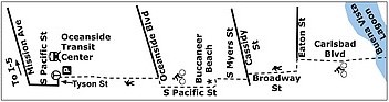
When completed, the Coastal Rail Trail will provide a Class 1 (fully separated) bikeway parallel to the NCTD line from the Oceanside Transit Center to the Carlsbad city limits. The trail currently stops at Oceanside Blvd., but the city has started design work on

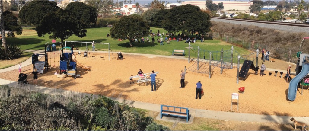
  1. crossing Loma Alta Creek at Buccaneer Park, completing the trail from Oceanside Blvd. to Morse.
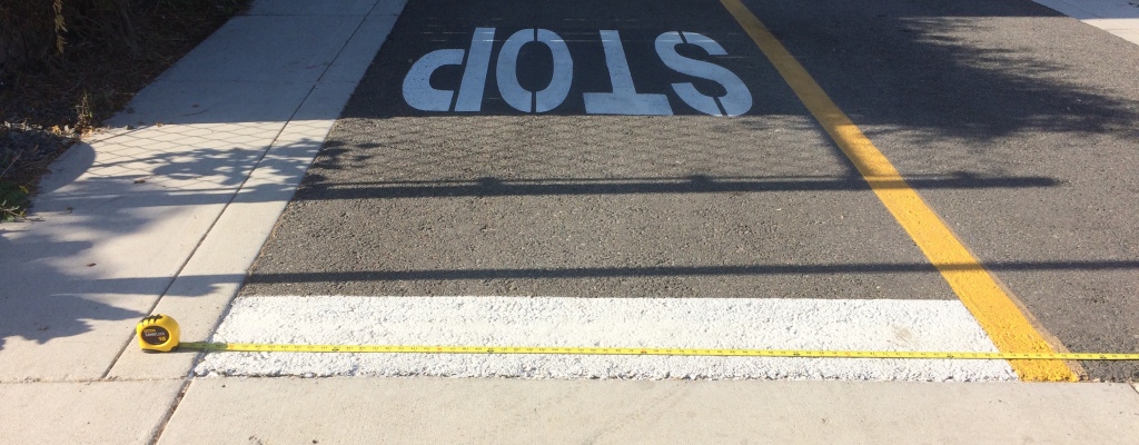
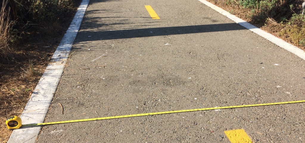
  2. replacing the substandard trail from Morse to Vista Way: the original trail built in 2003-2005 was only 8′ wide, instead of the 15′ standard on newer segments of the trail in Oceanside. The wider width is necessary to allow bidirectional travel and a mix of cyclists and pedestrian use.
  3. connecting south from Vista Way to the city limits; the current trail along Broadway dumps cyclists out on the street at Vista Way.
The planned Loma Alta Creek segment (#1) is the dotted green line, and existing South O trail (#2) is the solid green line.

Finishing (and upgrading) this rail trail has been a top priority for Save South O since 2017. This will be on the agenda for the July 25 South O community meeting (6:00-7:15pm at the Moose Lodge, 2017 S. Coast Highway).

South O Trail Upgrade

For #2 and #3 (the South O upgrade), council approved starting the alignment study in February, and work has begun on gathering public input to shape that design. There are two immediate opportunities for South O to make its voice heard in this process. See also the city’s Coastal Rail Trail website for future updates.

August 7 Workshop

On Monday August 7, the city is holding a 6:00-8:00 pm workshop at the Civic Center Library downtown. The city and its consultants will provide an update on the project, and it will be a time that South O (and other residents) can ask questions questions of both.

This is the first of two planned workshops (the other in February/March 2024) before the consultants unveil their proposed alignment in the summer of 2024.

Online Survey

To understand what Oceanside, Carlsbad and other residents want for the the South O upgrade, the city has posted a 14 question survey at http://bit.ly/OceansideCRT If you fill out the survey before August 7, you will both know the questions the consultants are asking and also influence their thinking at the event.

When you fill out the survey, here are two observations.

  • The survey doesn’t distinguish between South O and other 92054 residents. You should indicate in the remarks that you live in South O.
  • When I joined a group in taking the survey, the six categories for Q6 (“What are your top priorities”) was confusing. Some clarification of these categories:
    • Access & Mobility refers to the part of the trip when you are not on the trail (e.g., if you bike to the harbor, the part from your home to the trail and the part from the end of the trail to the harbor).
    • Equity is a two-part question, a general one about “serving all trail users”, and a specific one about “historically underserved populations.”
    • Feasibility & Timeline is asking if you are willing to give up some of your lower priorities to get the trail made sooner.
    • Safety was the only question that seemed clear to everyone.
    • Sustainability was also clear to most, when it refers to “environmentally sustainable design practices.”
    • Trail Experience refers both to whether you will enjoy using the trail, and also if the trail is attractive enough to others so they will use the trail.

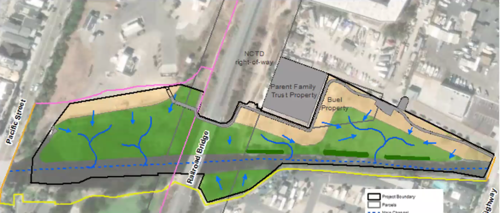
The alignment study will decide several questions about the preferred path through South O, which is not necessarily the same as the current trail. One key question is how the trail will connect from Eaton to the Coast Highway bike trail, since the Buena Vista Audubon Society has rejected the city’s request to have the trail connect south of Eaton using their lagoon property. Also, although the bulk of the trail (segment #2) is expected to utilize NCTD right of way, the question remains where exactly the trail will be placed along Myers and/or Broadway.

Finally, since the northern trail is west of the train tracks and the city’s southern terminus is west of the tracks, a key question is how does the trail cross the tracks? The options seem to be

  • Continue to cross the tracks at the existing Cassidy Street grade crossing;
  • Cross the tracks south of Cassidy Street, either under or over the tracks; or
  • Cross the tracks north of Cassidy Street, either under or over the tracks.

Crossing Loma Alta Creek

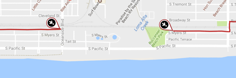
Today, the current CRT goes from the Oceanside Transit Center south to Oceanside Blvd. There is no connection from Oceanside Blvd. to the existing (narrow) ”rail trail” that begins at Morse St., between Myers and the NCTD tracks.

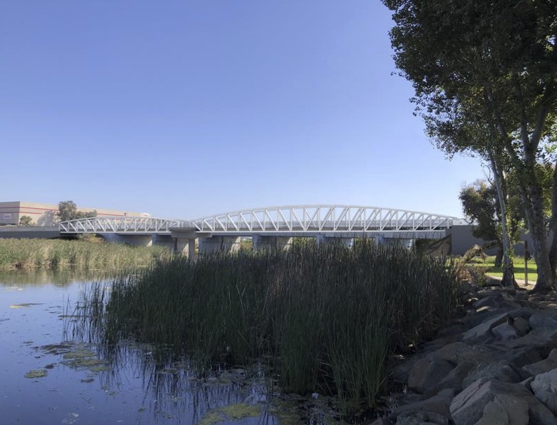
The city has approved connecting these two segments with a 255′ long bridge over Loma Alta Creek, starting to the existing trail at the south end of Buccaneer Park, and extending north from the bridge to Oceanside Blvd. The trail would be 14’ wide — 10’ paved, with 2’ of shoulder on each side (all paved on the bridge).

In May 2022 the total project cost was estimated at nearly $11 million, with 80% of that coming from a hoped-for grant from Caltrans. The state rejected the city’s first application, but the city is still seeking to eventually obtain state funding.

Attend Buccaneer Park Workshops: July 10, 22

Save South O has been pushing for more than two years to have the city provide a holistic plan of the various projects plan around and near Buccaneer Park:

  1. Completing the rail trail across Loma Alta Creek
  2. The Loma Alta Creek restoration project, including creation of a pedestrian trail on the north side of the creek
  3. Upgrading the bathrooms/restaurant building that serves Buccaneer Beach and Park
  4. Redevelopment of the unused 7 acres freed up by the planned closure of the La Salina Wastewater Treatment Plant

In particular, the city has (repeatedly) refused to commit to using all (or even some) of the WWTP land for parkland, even though both parkland (and parking for visitors to use the park) need to be expanded.

Representatives of Save South O met with Park & Rec staff, the city manager, and council members arguing that the city needs to develop a master plan before building anything at the site. The development of the site (like other projects) was slowed down due to COVID-19, allowing the planning process to catch up with the schedule for these various projects.

Update: The city has posted a survey about existing and future uses of the park. We encourage South O residents to push to expand Buccaneer Park using the land freed up by the closure of the WWTP.

The city has now committed to hold two public hearings about plans for the future of Buccaneer:

Workshop #1:

Date: Saturday, July 10th
Time: 10am – 2pm
Location: Buccaneer Park – 1506 S. Pacific Street, Oceanside, CA 92054

Workshop #2:

Date: Thursday, July 22nd
Time: 9am-1pm
Location: Main Street Farmer’s Market – Corner of Coast Highway and Pier View Way

We encourage South O residents to turn out en masse at these meetings to advocate both for expanding Buccaneer Park, and for a design that maximizes the availability for park land for use by South O and the community more generally.

Finishing the Rail Trail — the right way

On Thursday, October 29 the city will hold an online webinar to discuss plans to finish the “Rail Trail” over Loma Alta Creek. The city is discussing building the final missing link, from Oceanside Blvd. to Morse St., thus connecting the Oceanside Transit Center to the city’s southern border at Buena Vista Lagoon.

The webinar will be held from 5-6pm, using GoToMeeting or a call in number:

The Future of Buccaneer Park

The changes at Buccaneer over the next few years will permanently change the park, the neighborhood and South O. The rail trail is one of four projects at Buccaneer that Save South O is carefully monitoring:

  1. Restoration of the Loma Alta Slough
  2. Completing the rail trail with a new bridge over Loma Alta Creek
  3. Repairing/replacing the Buccaneer Park restrooms
  4. Redeveloping the La Salina Wastewater Treatment Plant

#3 and #4 have been designed although no noticed public hearings have been held.

Restoration of the Loma Alta Slough

#1 and #2 have external funding and are closest to completion. They are directly related because the trail along the Slough will pass under the rail trail bridge, and connect to the rail trail on the North side of the Slough.

At its Sept. 17 public webinar, the city discussed its site plan for the restoration project. Below is the diagram the city presented (Alternative 1) how the Slough trail (in gray) connected to the proposed “Rail Trail” (pink).

Completing the Rail Trail

Next week’s hearing will discuss the latest segment, which is billed as the final leg in Oceanside of the “44-mile bike trail between the City of Oceanside and the City of San Diego.” .

The trail was/is being built in four legs, beginning with South O:

  1. From the city limits to Morse Street — East of the tracks south of Cassidy, and West of the tracks north of Cassidy — which was finished in 2004.
  2. From Morse Street to Oceanside Blvd. (West of the tracks) — the subject of the current plans
  3. From Oceanside Blvd. to Wisconsin Street — completed in 2014
  4. From Wisconsin Street to the Transit Center — completed in 2013

However, parts of this trail — both existing and planned — are not suitable for serious bicyclists. Here we concur with earlier efforts by the Oceanside Bicycle and Pedestrian Committee to build all legs at a width suitable for high-speed cyclists to pass in opposing directions.

Map of Oceanside Rail Trail (bypassing leg #2) from the San Diego Reader (Sept. 4, 2019)

Putting Actual Bicycles on the “Bike Trail”

The key issue is the trail width. While the northern legs are a proper width, the original leg is not wide enough for cyclists (let alone cyclists and pedestrians) — nor is the planned leg along Loma Alta Creek.

Here is the newest leg at north side of Oceanside Blvd. where it is nearly 11′ wide (15.8′ with the concrete shoulders):

while here is the original leg where it crosses Whaley Street, where the asphalt is 7’ wide (8’ with shoulders):

After making its original mistake, the city now realizes that all remaining legs must be built to national bike path width specifications. In fact, in September 2017, the city’s (external) design engineers widened the planned trail over Loma Alta Creek from 12 to 14 feet at the request of the Bicycle and Pedestrian Committee. See Appendix F of the city’s Rail Trail Project Study Report (October 2017).

However — according to last month’s public webinar — the Loma Alta Creek trail is planned to be 6’ wide; this is closer to a standard sidewalk (5’) than than national standards or the remainder of the trail.

Save South O’s Position

Below is the letter that Save South O sent this week to the Loma Alta Creek project manager, arguing that when the city builds the Loma Alta Creek trail, it needs to be built at a proper width.

Subject: Correcting plans for trail along Loma Alta Slough
From: Save South O
Date: 10/22/20, 4:08 PM
To: Justin Gamble

Dear Justin,

Thank you again for hosting the meeting last month to update South O on plans for the Loma Alta Slough restoration project. I wanted to follow up on one point that came up during the hearing.

Regarding the trail planned to connect Coast Hwy to the Rail Trail and Pacific St.: when I asked how wide it would be, I was told 6′. This is a reasonable width for pedestrian only traffic, as our sidewalks are typically 5′ wide.

However, it is inadequate for a Class I bike path, let alone for a path intended to combine pedestrian and bicycle traffic as the sole crossing between Cassidy and Oceanside Blvd. For example, the southern end of the existing bike trail (at Oceanside Blvd) is 130″ wide, plus two concrete shoulders of 30″ for a total of 190″ (15′ 10″).

As attached, the city’s own analysis (made by Dokken in September 2017 for the Oct 2017 rail trail report) rejected a 12′ trail width as inadequate. Instead, it widened the bridge over Loma Alta Creek to 14′ to accommodate an expected mix of bicycle and pedestrian traffic. Quoting from the memo:

The AASHTO Bike Guide … recommends wider paths of 11 feet to 14 feet if:

  • Pedestrians comprise 30% or more of path traffic,
  • The total volume of path users (all types) in the peak hour exceeds 300, or
  • There is significant use by in-line skaters, children or trike riders.

Meanwhile, the “bike path” built 15 years ago between Eaton and Morse is only 7′ wide (8′ with shoulders) and is effectively a sidewalk, used by pedestrians, strollers, and families with children. Adult bicyclists do not use the path because it is not wide enough for cyclists to pass at normal speeds, even if there are no pedestrians or children on the path.

To avoid wasting money as was done on the first leg of the rail trail, I ask the city to revise its plans for a trail along Loma Alta Creek to use a width consistent with to the newer (Oceanside Blvd) segment of the rail trail, the bridge over Loma Alta Creek, and the AASHTO guidelines quoted by the city’s October 2017 Project Study Report.

Joel

The future of Buccaneer

The future of Buccaneer Park was on the agenda of the South Oceanside Community and Merchants Association. The city has three projects going forward:

  1. Redeveloping the La Salina Wastewater Treatment Plant
  2. Restoration of the Loma Alta Slough
  3. Repairing/replacing the Buccaneer Park restrooms

The first of these three items was the subject of the today’s presentation at Beach Break Cafe, by Lindsay Leahy, principal water engineer of the city’s water utilities department.

IMG_8831-cropped
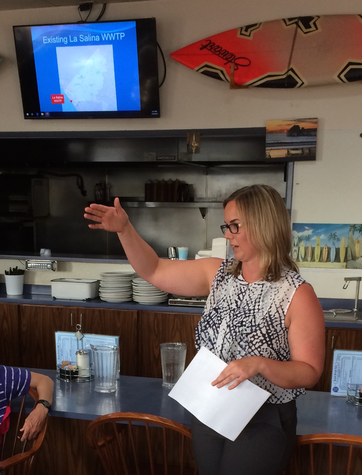
The specific project presented was the decommissioning of the La Salina WWTP. Rather than upgrade the plant built in 1949, the city decided in 2014 to close it. However, closing this requires building a lift station to take all the sewage that flows via gravity to from South O, Fire Mountain and downtown, and pump it back to the San Luis Rey WWTP built in 1972.

This will require building a new return pipe under Oceanside Blvd. to Garrison Blvd. It also requires building a pump station at the La Salina site, and both have to be working before La Salina can be decommissioned in 2022 (perhaps by the end of 2022).

Future of Buccaneer

On the west side, the future of Buccaneer depends on getting sand back on Oceanside beaches. Currently the city is prioritizing sand around the pier over the rest of the city.

However, the La Salina decommissioning will free up 2/3 of the 10.6 acre side, located between the railroad tracks and Pacific St, north of Loma Alta Creek. The current sketches show 66 parking spaces as part of the pump station construction. The city has not announced (or even decided) its plans for the remaining 7 acres.

Loma Alta Wetlands-La Salina 04-2019
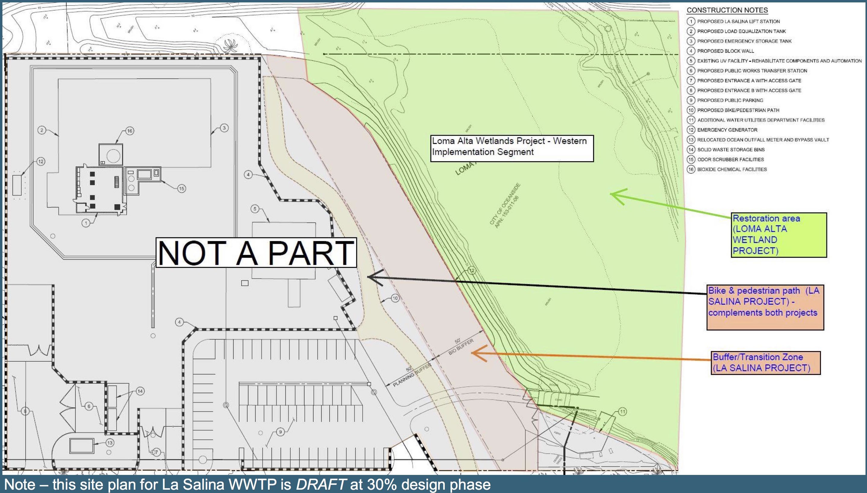
The creek (slough) restoration one of the 100 or so sites being restored by the Southern California Wetlands Recovery Project. In addition to wetlands restoration, it will also include additional walking and/or bike trails along the north side of the creek. The wetlands project is the subject of an August 15 workshop from 5-7 p.m at the downtown library.

Finally, the city is long overdue to fix the decrepit bathrooms at Buccaneer. Leahy said the city will issue an RFP to study this remodeling.

Public input for all three projects will be sought in the remainder of 2019 and throughout 2020. It appears that the use of the unused part of La Salina — crucial to the future of Buccaneer and South O — will be subject of later hearings.

Next step in completing Rail Trail

One of goals of the Coast Highway “road diet” is to make lanes for bicycles. But as California bicycle safety standards make clear, a Class II bike lane is not as desirable (or as safe) as a Class I separated bike path.

The Coastal Rail Trail is a planned 44-mile route from Oceanside to San Diego’s Santa Fe Depot. It is one of the major bicycle priorities for SANDAG and the coastal cities along the route. Oceanside is doing better than most of the county, with most of the stretch completed from the Oceanside Transit Center to the city’s southern border.

TrailLink - Rotated closeup

In April 2005, the city completed a stretch from Vista Way to Morse (along Broadway and then Myers). A second stretch, from Oceanside Blvd. to Tyson St. (the OTC) along the east side of the tracks, was built from 2012-2015. At the south end of the city, there is a physically separated lane that parallels Coast/Carlsbad Boulevard across Buena Vista Lagoon.

The one gap is the stretch between Morse and Oceanside Boulevard, across Loma Alta Creek. The long-distance cyclists ride on Pacific Street, but between beachgoers and auto traffic, this is hardly optimal — and makes it hard to rejoin the trail at Oceanside Boulevard. Completing this stretch also makes a safer (Class I) path through South O than any Coast Highway bike lane can ever provide: as long as there are cars driving along (and entering and leaving) Coast Highway, these bike lanes will never be as safe as a fully separated bike path.

Completing the trail across the creek has been on the city’s planning radar for several years, and it now appears that the project is once again moving forward. On May 13, the city will hold an open house about the missing segment from 10:00-12:00 noon at Buccaneer Park. The city and its consultant, Dokken Engineering, will be discussing alternative locations for the connecting trail and bridge across the creek, and is inviting cyclists, community members and other interested parties to attend. For more information or to RSVP, see the city’s flyer.