
On Thursday, October 29 the city will hold an online webinar to discuss plans to finish the “Rail Trail” over Loma Alta Creek. The city is discussing building the final missing link, from Oceanside Blvd. to Morse St., thus connecting the Oceanside Transit Center to the city’s southern border at Buena Vista Lagoon.
The webinar will be held from 5-6pm, using GoToMeeting or a call in number:
- https://global.gotomeeting.com/join/922414485
- Phone Number: (408) 650-3123 Access Code: 922-414-485
The Future of Buccaneer Park
The changes at Buccaneer over the next few years will permanently change the park, the neighborhood and South O. The rail trail is one of four projects at Buccaneer that Save South O is carefully monitoring:
- Restoration of the Loma Alta Slough
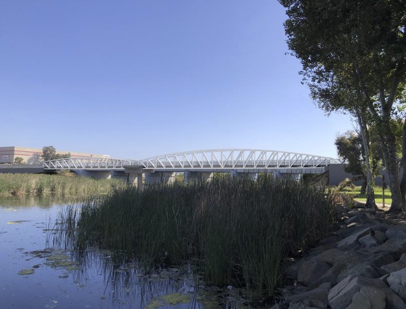
- Completing the rail trail with a new bridge over Loma Alta Creek
- Repairing/replacing the Buccaneer Park restrooms
- Redeveloping the La Salina Wastewater Treatment Plant
#3 and #4 have been designed although no noticed public hearings have been held.
Restoration of the Loma Alta Slough
#1 and #2 have external funding and are closest to completion. They are directly related because the trail along the Slough will pass under the rail trail bridge, and connect to the rail trail on the North side of the Slough.
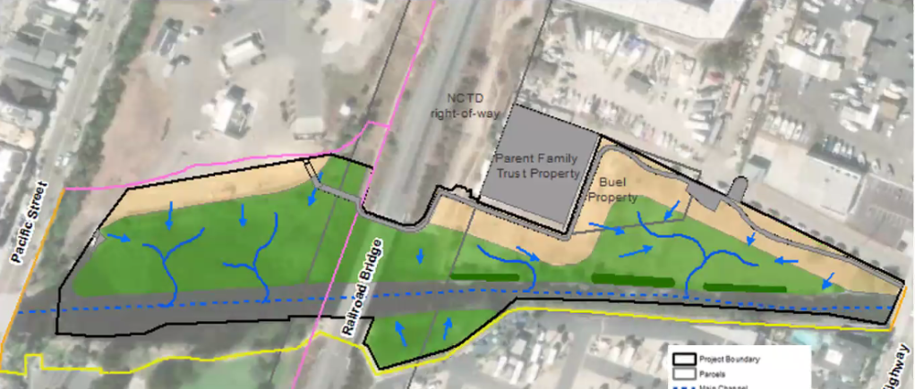
At its Sept. 17 public webinar, the city discussed its site plan for the restoration project. Below is the diagram the city presented (Alternative 1) how the Slough trail (in gray) connected to the proposed “Rail Trail” (pink).
Completing the Rail Trail
Next week’s hearing will discuss the latest segment, which is billed as the final leg in Oceanside of the “44-mile bike trail between the City of Oceanside and the City of San Diego.” .
The trail was/is being built in four legs, beginning with South O:
- From the city limits to Morse Street — East of the tracks south of Cassidy, and West of the tracks north of Cassidy — which was finished in 2004.
- From Morse Street to Oceanside Blvd. (West of the tracks) — the subject of the current plans
- From Oceanside Blvd. to Wisconsin Street — completed in 2014
- From Wisconsin Street to the Transit Center — completed in 2013
However, parts of this trail — both existing and planned — are not suitable for serious bicyclists. Here we concur with earlier efforts by the Oceanside Bicycle and Pedestrian Committee to build all legs at a width suitable for high-speed cyclists to pass in opposing directions.
Putting Actual Bicycles on the “Bike Trail”
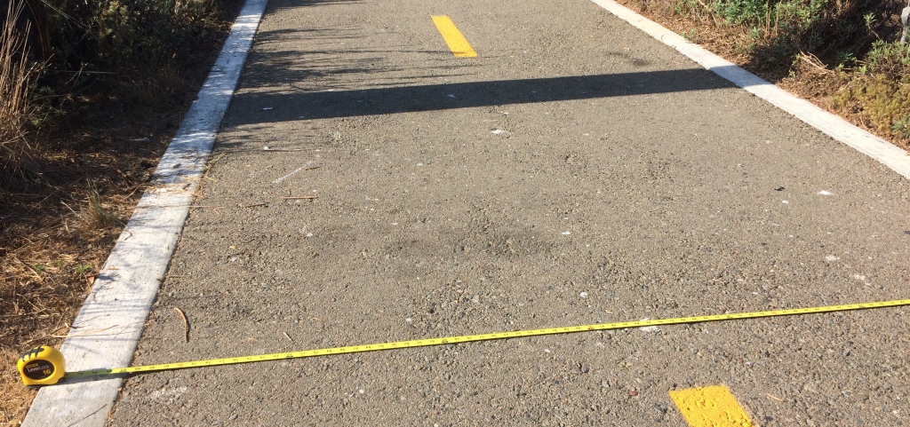
The key issue is the trail width. While the northern legs are a proper width, the original leg is not wide enough for cyclists (let alone cyclists and pedestrians) — nor is the planned leg along Loma Alta Creek.
Here is the newest leg at north side of Oceanside Blvd. where it is nearly 11′ wide (15.8′ with the concrete shoulders):
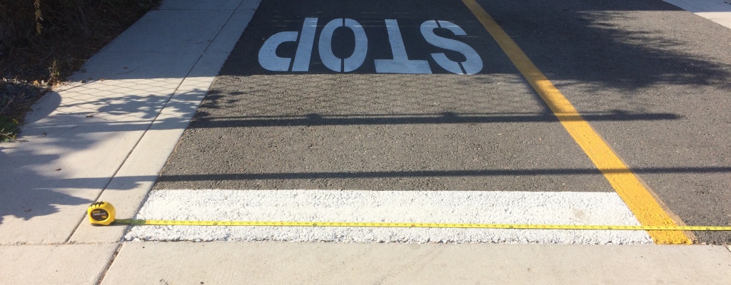
while here is the original leg where it crosses Whaley Street, where the asphalt is 7’ wide (8’ with shoulders):
After making its original mistake, the city now realizes that all remaining legs must be built to national bike path width specifications. In fact, in September 2017, the city’s (external) design engineers widened the planned trail over Loma Alta Creek from 12 to 14 feet at the request of the Bicycle and Pedestrian Committee. See Appendix F of the city’s Rail Trail Project Study Report (October 2017).
However — according to last month’s public webinar — the Loma Alta Creek trail is planned to be 6’ wide; this is closer to a standard sidewalk (5’) than than national standards or the remainder of the trail.
Save South O’s Position
Below is the letter that Save South O sent this week to the Loma Alta Creek project manager, arguing that when the city builds the Loma Alta Creek trail, it needs to be built at a proper width.
Subject: Correcting plans for trail along Loma Alta Slough
From: Save South O
Date: 10/22/20, 4:08 PM
To: Justin Gamble
Dear Justin,
Thank you again for hosting the meeting last month to update South O on plans for the Loma Alta Slough restoration project. I wanted to follow up on one point that came up during the hearing.
Regarding the trail planned to connect Coast Hwy to the Rail Trail and Pacific St.: when I asked how wide it would be, I was told 6′. This is a reasonable width for pedestrian only traffic, as our sidewalks are typically 5′ wide.
However, it is inadequate for a Class I bike path, let alone for a path intended to combine pedestrian and bicycle traffic as the sole crossing between Cassidy and Oceanside Blvd. For example, the southern end of the existing bike trail (at Oceanside Blvd) is 130″ wide, plus two concrete shoulders of 30″ for a total of 190″ (15′ 10″).
As attached, the city’s own analysis (made by Dokken in September 2017 for the Oct 2017 rail trail report) rejected a 12′ trail width as inadequate. Instead, it widened the bridge over Loma Alta Creek to 14′ to accommodate an expected mix of bicycle and pedestrian traffic. Quoting from the memo:
The AASHTO Bike Guide … recommends wider paths of 11 feet to 14 feet if:
- Pedestrians comprise 30% or more of path traffic,
- The total volume of path users (all types) in the peak hour exceeds 300, or
- There is significant use by in-line skaters, children or trike riders.
Meanwhile, the “bike path” built 15 years ago between Eaton and Morse is only 7′ wide (8′ with shoulders) and is effectively a sidewalk, used by pedestrians, strollers, and families with children. Adult bicyclists do not use the path because it is not wide enough for cyclists to pass at normal speeds, even if there are no pedestrians or children on the path.
To avoid wasting money as was done on the first leg of the rail trail, I ask the city to revise its plans for a trail along Loma Alta Creek to use a width consistent with to the newer (Oceanside Blvd) segment of the rail trail, the bridge over Loma Alta Creek, and the AASHTO guidelines quoted by the city’s October 2017 Project Study Report.
Joel

2 thoughts on “Finishing the Rail Trail — the right way”