
At Wednesday’s City Council hearing (Item #22), the council will vote formally on a plan developed in the South O community to expand pedestrian, bicycle and car access along NCTD right-of-way.
This is a win-win-win for South O residents. While there has been no controversy so far, South O residents need to email the city council by Tuesday night to make sure it is not derailed by last minute hesitation or objections. (We also expect a few residents will attend the 6pm public hearing). Residents should say they favor the city’s proposed agreement with NCTD to use this land to improve recreation and transportation options for South O residents.
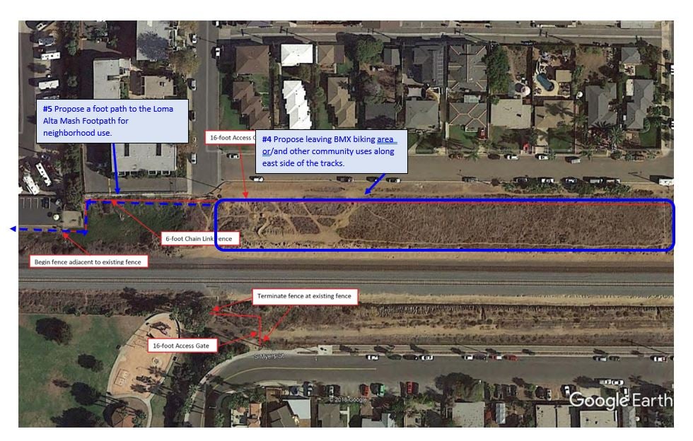
This is tied to NCTD’s ongoing project to reduce fatalities from pedestrians crossing their RR tracks. As part of this, NCTD will add fences on both sides of its tracks between Morse and Eaton, i.e. on ether side of the Cassidy Street RR crossing. This is intended to prevent people from crossing the NCTD tracks, except at the Cassidy crossing and and the underpass at Loma Alta Creek.
Reuse of NCTD Land Near Cassidy Street
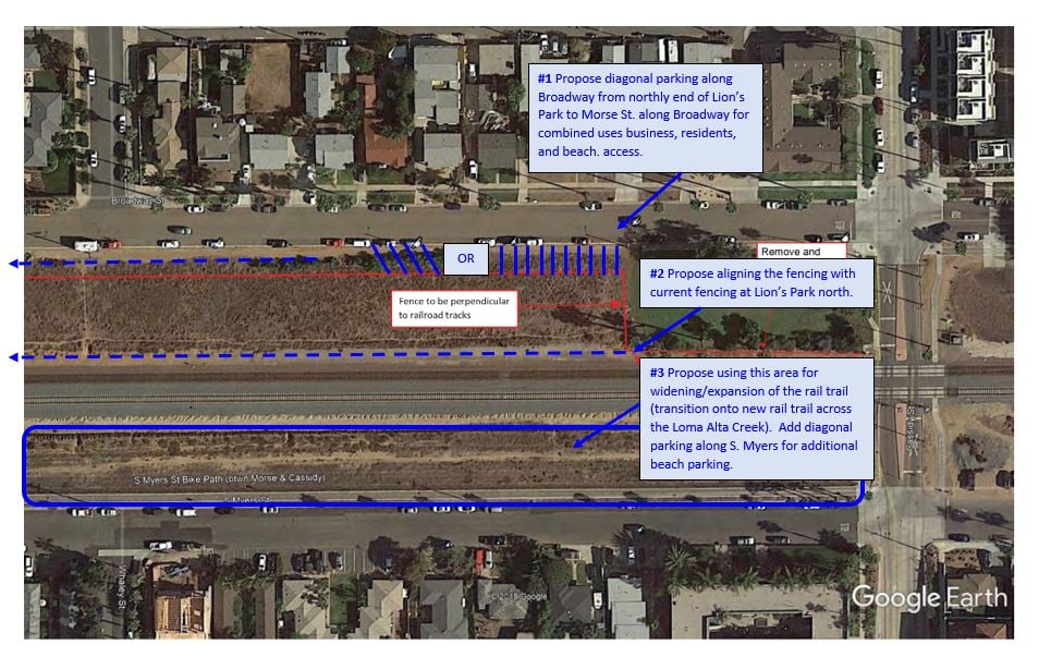
The South O proposal modifies the original NCTD plan to move the fences closer to the tracks, to keep some of the existing pedestrian paths, allow for right-angle (or diagonal) parking along Broadway between Morse and Cassidy, and make room for future widening of the Coastal Rail Trail. It also calls for a pedestrian footpath from the end of Morse Street down to the existing Loma Alta Creek bike/pedestrian trail.
As a result of the South O-city-NCTD discussions, NCTD will move some of their fences closer to the tracks to make more land available to South O. Wednesday’s vote is for the city to appropriate $350k in its 2021-2022 capital improvement budget for costs that NCTD will not bear, but must be paid by the city: adding the Broadway parking and creating the pedestrian footpath.
This plan was supported by South O community members at meetings earlier this year, including a January 21 meeting with Deputy City Manager Jonathan Borrego. Save South O and other South O community leaders are pleased by how cooperative both the city and NCTD have been on modifying the original NCTD plans to improve the availability of the land for local residents.
Staff Report
Synopsis
Staff recommends that the City Council approve a Memorandum of Understanding and License Agreement with the North County Transit District (NCTD) regarding City use of property owned by the North County Transit District located on the west side of Broadway Street between Morse Street and Cassidy Street; and authorize the City Manager to execute all related documents.
Background
Last year NCTD completed a Trespasser Risk Assessment study that evaluated the incidence of railroad right of way trespassing within the Cities of Oceanside, Encinitas and Del Mar. … Upon completion of the study, NCTD shared a proposed fencing plan with City staff that included the installation of 6-foot high, black vinyl coated chain link fencing on the east and west sides of the railroad right of way, generally between Morse Street to the north and Buena Vista Lagoon to the south.
Prior to the fencing plan being presented to NCTD’s Board of Directors for approval, staff was contacted by a South Oceanside resident inquiring as to whether the fencing could be sited in a manner that would allow for additional parking along Broadway Street, between Morse Street and Cassidy Street. The resident also suggested that a similar design be considered for Myers Street in a manner that would also accommodate a possible widening of the Coastal Rail Trail. This could be accomplished by locating the fencing inward towards the railroad tracks as opposed to placing the fencing along the outward edges of the railroad right of way. The resident also requested that staff explore the feasibility of creating a pedestrian trail that would run from the western terminus of Morse Street, northward along the railroad right of way and connecting to the pedestrian rail undercrossing at Lorna Alta Creek.
City staff discussed these proposals with NCTD and their staff expressed a willingness to relocate the proposed fencing in a manner that would accommodate these options subject to the City agreeing to maintain and assume liability for those portions of the NCTD right of way that the City would like to improve with parking and/or trails.
The recommended Memorandum of Understanding (MOU) and License Agreement (Agreement) would address the portion of NCTD right of way along Broadway Street between Morse Street to the north Lyons Park to the south and as further discussed below. White staff intends to further explore the Myers Street and pedestrian trail proposals, those improvements require significant further study and separate license agreements with NCTD could be pursued as those projects move forward.
Analysis
The proposed fencing plan for the Broadway Street area is included as Attachment 1. While members of the public have suggested that the area be improved as parking to the benefit of the adjacent neighborhood and beach visitors, staff believes there is enough land area available to accommodate both parking and a potential walking path or other public amenities. including a possible expansion to Lyons Park. At the request of the community, the informal BMX track area near Morse Street will be preserved to the maximum extent possible.
Prior to proceeding with the formal design of any improvements to the area, staff intends to solicit input from the surrounding community to ensure that their ideas for improvement are considered and that any areas of concern are addressed. If parking is to be allowed within the NCTD right of way, measures could be taken to prevent oversized vehicles from parking in the spaces as the City often receives complaints about oversized vehicles parking on Broadway Street for extended periods of time. At this time, the MOU and Agreement only pertain to the fence location. Any further improvements will require future City Council approval.

Please allow for widining of rail trails as agreed upon in prior meeting with SouthO and fence setbacks also too much high density building is being allowed. And parking on nctd should be allowed but not for oversized vehicles and long term overnight parking and camping I.e living. A safety and health issue for residents. Also improve ra tra and get bikes off coast hwy. I think they’ve taken up many options for little use and we use cars. We need to address what is actually being used and be practical we’re not going to drive elderly and families around on bikes. Let our tax dollars be used by the ones who
Pay for it and not people from other areas used for recreation activities like bikes.
LikeLike
Nancy, we are working with the city to make sure that land will be available for widening the Rail Trail up to the 14′ standard, even if it doesn’t come out of the budget for this round. There has been discussion (but no promises) that the right-angle parking along Broadway would foreclose its use for oversize vehicles. But such issues are why we hope that residents will email the council and speak out at public hearings.
LikeLike