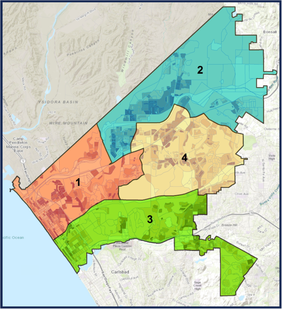
The city is in the middle of its decennial redistricting effort, to realign city council district boundaries to equalize the size of the various districts. City Clerk Zeb Navarro visited South O on Jan. 25, to highlight the 2022 redistricting effort for the bimonthly meeting of the South Oceanside Community and Merchants Association.
On Wednesday Feb. 2, the hearings and workshops will make their only appearance in South O’s district (District 3), in a 6pm workshop at Lincoln Middle School, 2000 California St., Oceanside.
As in previous years, the boundaries must be set (according to state law) to have similar population, contiguous territory, follow natural boundaries, and respect communities of interest.
City Council District boundaries, 2017-2021
When the first districts were picked in 2017 — in response to a threatened lawsuit by a shakedown lawyer — Save South O was involved in the process. In the midst of South O’s (largely successful) fight against imposing the Coast Highway “Road Diet” on South O, we asked to be placed in a different district than Seaside/Townsite, where residents sought the Road Diet (less cars, less road capacity, more walking/bikes). That desire was granted, in that the northern boundary of District 3 is Oceanside Blvd, and almost all of the area South of Oceanside Blvd. is in District 3.
District 3 is now the biggest district in the city and nearly 5% too big. The city’s 174,578 residents call for four districts of approximately 43,645 residents, so any approved plan must shed (about) 1,968 residents from District 3. (Under US law, districts are determined by residents and not voters).
Because Communities of Interest are an important (and difficult to define) construct, residents are encouraged to use the process to submit their own boundaries for Communities of Interest (COI) that should be used in setting boundaries. The city uses this definition:
A COI is a group of people in a defined geographic location that share a common bond or interest. A Community of Interest is defined as “a contiguous population which shares common social and economic interests that should be included within a single district for purposes of fair and effective representation.” Please tell us what defines your Community of Interest, where it is located, and why it should stay together.
For example, most South O residents would consider South O and the West side of Fire Mountain to share a Community of Interest — in terms of schools, traffic, freeway access, and shopping.
If possible, residents should attend Wednesday’s hearing. No matter what, residents are encouraged to submit their information (using the city’s process) no later than Feb. 10, so that it is considered in making the initial draft maps.
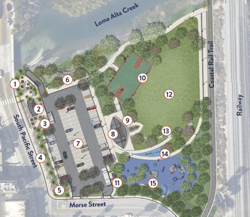
This Thursday at 6pm in the Community Room of the downtown library, the City will unveil its latest thinking on the “Buccaneer Park Re-visioning.” There are a few problems:
The meeting is scheduled against the weekly Sunset Market (5-9pm), so parking will likely be difficult.
One of the two plans is unsafe, something that the consultants and the city didn’t notice before drafts were shared with South O reps this week.
The proposal says nothing about how the revised park will connect to new parkland on the site of the (soon to be closed) La Salina treatment plant — the whole point of Save South O’s repeated calls for a Buccaneer Park master plan.
Still, the proposal give the community a chance to see the city’s thinking and offer feedback for the existing Buccaneer footprint east of Pacific and south of Loma Alta Creek.
Reject Concept #2
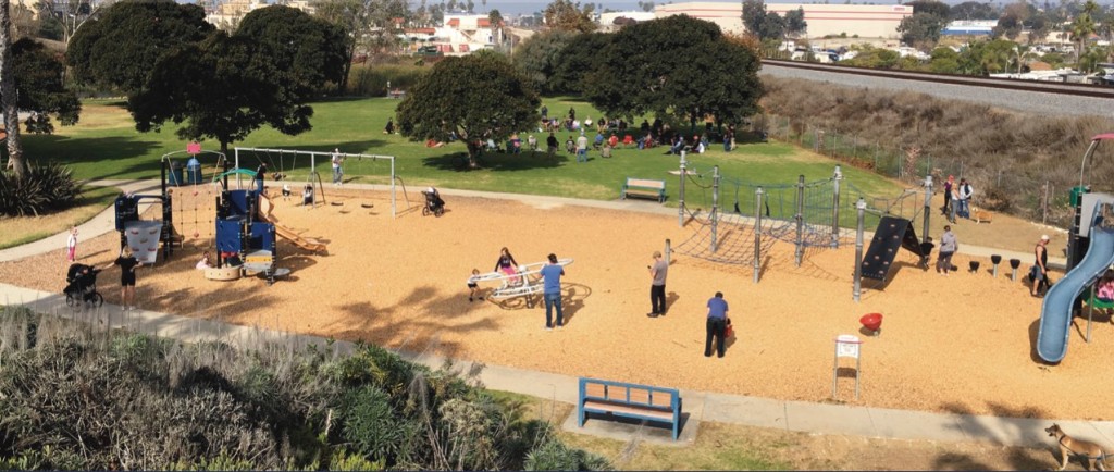
The consultant prepared two concept proposals. Save South O recommend immediate rejection of Concept #2, because it moves the playground (for 2-5 and 5-12 year-olds) next to Pacific Street. Any parent who’s lost track of their child for 30 seconds — or watched a kid chase a ball into the street — would understand why this is an unnecessarily dangerous plan for exactly those families it intends to serve. It is inexplicable that this idea has gotten this far without someone calling out the potential risk.
Concept #1
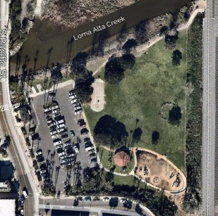
Below are the “Concept #1” plan, along with an aerial view of the existing park
The major changes
Moving the restroom from the west to east side of the parking lot
Expanded/reworking of the playground area
Some additional space around the concessionaire (Buccaneer Cafe).
Some potentially controversial choices (based on informal discussions):
No more shower in the bathroom. The city could have a shower inside, a shower outside, or no shower (relying on the existing shower on the beach to shower off).
The option (during busy times) to move the coffee cart away from the Cafe.
The addition of a basketball court reduces the existing park area.
The city has a series of questions about the proposed design.
Save South O has been pushing the city since 2019 to reveal the complete picture of what is going on around Buccaneer Beach and Park. This workshop
Does not show reuse for the La Salina plant. Our consistent position has been that South O needs to know what uses are planned for north of Loma Alta Creek before rebuilding the existing park. (For example, basketball, tennis or pickleball are separate uses not tied to the existing beach or picnic area that would make more sense in the La Salina location).
Does not show the Creek restoration (where the city already has a grant)
Does not show the rail trail (although it leaves room for it)
The Save South O recommendation: the city should hold off implementation of any Buccaneer Park redesign until it can share a complete vision for all of Buccaneer Park—including any expansion until the former La Salina plant.
Save South O and other community groups around the state are circulating petitions to put the “Our Neighborhood Voices” initiative (also called the Brand-Huang-Mendoza Tripartisan Land Use Initiative) on the November 2022 state ballot. The goal of this is to stop recent efforts by Sacramento politicians to usurp local land use decisions, forcing cities to accelerate property development without regard for local conditions or concerns.
The grassroots support for this measure makes it almost certain it will qualify, but that’s just the beginning of the battle. Local neighborhoods and cities will be outspent 10:1 or even 100:1 by developer interests who will distort the bill as anti-housing or who knows what other lies. Thus, we will need to go door to door to make sure every voter in our city understands what this fight is about and why this measure is essential.
We plan to start signature gathering later this month, so if you are interested, please contact us directly.
The proposed 54-unit (“mixed use”) condominium project at 1602 S. Coast Highway was approved by the Planning Commission’s second hearing October 11. That approval was appealed by South O residents to the council, which will hear the appeal on Wednesday; we are asking for changes to the project to improve its safety, compatibility with South O (per coastal regulations) and to insure that the units are actually used for housing.
The hearing (on Item 28) is being held at 6pm (time certain) in the City Council chambers, 300 North Coast Highway, Oceanside. While the hearing can be viewed online via KOCT, those testifying must appear in person. South O residents are asked to wear their Save South O t-shirts (email if you want one delivered) or wear blue.
The project is unprecedented in its height, density and scale — and, if approved, will set a precedent that all future developers will seek to follow. South O is strongly opposed to this project — to a degree not previously seen since the proposal to shrink Coast Highway from 4 lanes to 2. Whether or not you attend, please email the city council to ask they approve the appeal (sending the project back for changes) citing one or more of the issues listed in our appeal.
City staff have claimed that while they don’t like the project, their hands are tied and they must approve it under state law; the council is currently undecided. Save South O and its supporters have identified specific ways in which the project is contrary to existing development law, which are listed in our appeal. Only categories listed in the appeal can be cited; the eight categories are:
Public safety, particularly how the project will impact traffic safety on Freeman and Morse. The developer has asked for a waiver from the city from the requirement to provide a 15′ setback on Freeman. We ask that the city reject the waiver, which would create future accidents from cars leaving the building that cannot see pedestrians, motor vehicles and bicycles (particularly high-speed e-bikes) on Freeman.
Parking, which with 64 spaces for 54 2- and 3-BR units, is clearly inadequate for the project.
Short Term Vacation Rentals. The developer is allowed to increase the project from 40 to 54 units because it’s providing 5 very low income units. However, the developer refuses to permanently restrict those 54 units from being used as STVRs (which would then allow that housing to be converted into visitor-serving short-term rentals).
Non-Compliance with the California Coastal Act, because it is incompatible with the city’s Local Coastal Plan and Land Use Plan which states that “The City shall ensure that all new development is compatible in height, scale, color and form with the surrounding neighborhood.” The 4-story project is clearly not compatible in height, scale and form with adjacent 1- and 2-story single family residences.
Precedent. Approval of this project would allow other developers to argue for their right to ignore the LCP, LUP and other city policies.
Commercial Use. The only way residential use is allowed on Coast Highway is as part of a “mixed use” project, with both residential and commercial usage. However, the developer has testified that if the commercial space is not rented, it could be used for residential purposes — and thus this “mixed use” project would be a purely residential project not allowed by existing zoning.
Transition between Commercial and R1 Neighborhood. The LCP and LUP requires “adequate buffers or transition zones” between the commercial area and surrounding single-family neighborhoods, but the project does not.
Walkability. The city’s policies are to encourage walkability along Coast Highway, both downtown and in South O. South O has requested some form of outdoor seating but the developer declined to do so.
This weekend marks the latest round in the fight against 1602 S. Coast Highway, a proposed 54-unit, 42′ tall condo project that with traffic, density, parking and height would permanently change the character of South O (and set a precedent for other projects to do so):
On Saturday, there is a rally at Marshall Street Park from 10am – noon. Residents will be making signs for the PC hearing. Save South O will be selling t-shirts at cost ($5/each) so residents can clearly signal at the hearing what side they are on.
At 6pm Monday, this will return for a second time to the Planning Commission. While people can watch on Zoom or KOCT, under new city policies, only those present at the council chambers (300 N. Coast Highway, Oceanside) will be allowed to testify.
Sept. 27 PC Hearing
We had a good turnout of South O residents at the Sept. 27 hearing, both in person and online. The community members made strong arguments (summarized here) about why the project is not appropriate for South O, and needs to be sent back for changes to reduce its impact.
South O residents living nearby talked about the existing traffic and pedestrian safety issues that will be exacerbated by this 54-unit project, as well as the impact of a 42′, 4-story building looking down on their homes. Others focused on how it is under-parked, and that everyone in the room knew that — despite the parking/density bonuses of being a half mile from the Sprinter station — the residents will have more cars than parking spaces and will spillover into neighborhood streets.
But fundamentally, a majority of the PC agreed that this project is not consistent with the character of the local community. As Oceanside’s 1985 Local Coastal Program Land Use Plan (p. 34) states:
The Coastal Act requires that the visual qualities of the Coastal Zone shall be protected and that new development be sited and designed to be visually compatible with the character of surrounding areas.
On Sept 27, the PC leaned 3-1 to send the plan back for revision. However, the city planner used a procedural move to create a tied vote so that it could be reconsidered on Oct 11 (this Monday) when more PC members would be present. These PC members have not heard the testimony from Sept 27, and the one commissioner (Louise Balma) appeared to be on the fence while two (Robin Goodkind, Jolene Hayes) were opposed and the fourth (Tom Morissey) strongly supported it.
Going Forward
The developer and its land use consultant have made clear that they have no intention of negotiating any substantive changes with the city — over density, scale or parking — unless forced to do so by the city. If they lose on Monday, their clear plan is to take the existing project to the council and demand that it approve the project. That council meeting would likely be in November or early December.
Similarly, if South O loses on Monday, we will ask the council to hear our appeal. The stakes in this project are too high, as having a wall of such projects along Coast Highway would clearly destroy the unique character of South O. Other projects are in the pipeline, waiting to see what happens on this project and the maximum density they can cram into their planned projects.
We ask all South O residents to attend in person, email comments in advance (by noon Monday) to PlanningCommission@oceansideca.org, or both.
For almost five months, South O residents have been fighting plans for a massive (and unprecedented) condo project at 1602 S. Coast (SE corner of Morse and Coast). It comes before the Planning Commission Monday at 6pm: the public can participate in person, via zoom, phone or emailed comments.
This project has unprecedented scale and density for any South O development on Coast Highway. If the Planning Commission follows the staff recommendation, this project will set a precedent to change permanently change the character of South O.
Summary
The staff report is recommending approval of the 54 unit project at the SE corner of Morse and Coast Highway. The report says that the developer, Hallmark Development of Solana Beach, held outreach meetings with the community, which it did (via Zoom) on April 14 and May 4.
What it doesn’t say is that the developer made no substantive changes to the areas where South O residents fiercely objected: height, scale, density and inadequate parking.
This proposed development would be compatible with surrounding developments in terms of land use, density, and lot size. The proposed four (4) story mixed use development is consistent with many of the existing and proposed mixed~use developments along South Coast Highway. The existing developments within the neighborhood range from one to two-story single-family and two to three story multi-family complexes, commercial and office developments.
In other words, a new 4 story, 42′ tall condo project is “compatible” with the neighborhood.
Of all the commercial development on Coast Highway from Morse Street to the city limits, there is exactly one building taller than two stories: the portions of the abandoned Blade-Tribune building near Cassidy St. So there is no precedent for a 4-story, 42′ building.
The residential development east of Coast between Morse and Cassidy is 1- and 2-story single family homes and apartments. The proposed project will dwarf and shadow this neighborhood unlike any others.
Unprecedented Density
The report says the Morse Street Townhomes (north of Morse, east of Coast) sets a precedent for this project.
The Morse Street Townhome project located directly north from the project site along Morse Street was recently developed as a three-story condominium project and is similar in terms of density, scale, and architectural features
However, a cursory comparison of these two projects shows that the new project has unprecedented density (more than 3x as large) and scale (both in terms of height and lot coverage):
Morse Street Townhome
1602 S. Coast
Area
2.3 ac
0.9 ac
Height
34.5′
42.0′
Stories
3 plus roof deck
4 plus possible deck
Units
38
54
Density
16.5 du/ac
59 du/ac
Commercial
0
3,300 sq ft
Parking
83 spaces
77 spaces
Lot coverage
33%
86%
The report also claims that “the proposed development … is consistent with the goals of the Coast Highway Corridor Study and Coast Highway Vision and Strategic Plan.”
However, the use of a project north of Morse is a red herring. The staff knows full well that while the 2007 Coast Highway Vision called for increased density along Coast, when the council voted in August 2019 to enact that vision, it voted to eliminate density and development incentives from all property south of Morse Street. So city development policyNorth of Morse is different from that South of Morse. (Just as development policy West of Coast is different from that East of Coast).
Inadequate Parking
The project has 34 2BR units, 20 3BR units and 64 residential parking spaces. In addition it has 11 spaces for commercial use and 2 guest parking spaces.
According to the April 14 community meeting, developer is expecting to sell these condos for $600-800k. However, it is claiming that the residents won’t own as many cars as elsewhere in the city, because it is 0.4 miles from the Sprinter station at Godfrey Street. Given people buying these condos will (under HUD guidelines) need a household income of $60,000-80,000/year, any survey or study of homeowners in Coastal Oceanside would suggest that (as with other SoCal suburbs) most residents will have one car per adult.
One thing that the Morse Townhomes have shown: inadequate parking in the residential project (which makes the project more profitable for the developer) will flood local streets with the overflow. This was the single greatest objection by residents at the May 4 community meeting.
Even if residents will learn how to use mass transit, AirBNB visitors from other cities are unlikely to do so. (Neighbors of Short-Term Rentals will also tell you that visitors to such properties often cram as many people with as many cars as possible.) The city and the developer refused to add a deed restriction banning STR rentals at this under-parked property.
How to Participate
If approved, this project will set a precedent for all future Coast Highway redevelopment. You can participate in the hearing:
In person: Council Chambers (2nd floor), 300 N. Coast Highway, Oceanside
Via the Internet: https://zoom.us/ ; to join, click “Join a Meeting” at the top of the Zoom webpage. Enter the Zoom Meeting ID: 881 1127 3720
Via telephone: (669) 900-6833, and then enter the meeting ID. (Mute your phone unless you are called on)
A. Land Use Element Goal 1.12 Land Use Compatibility Objective: To minimize conflicts with adjacent or related uses. Policy B: The use of land shall not create negative visual impacts to surrounding land uses. The proposed mixed~use development would create a 54 unit residential condominium units and 3,244 square feet of ground floor commercial space and would implement the goals and objectives specified in the General Plan and be in compliance with the State Density Bonus goals of maximizing density. The project meets all required development standards of the C~21CZ zoning district, with the exception of the two (2) requested waivers of the aforementioned development standards as permitted under State Density Bonus Law. This proposed development would be compatible with surrounding developments in terms of land use, density, and lot size. The proposed four (4) story mixed use development is consistent with many of the existing and proposed mixed~use developments along South Coast Highway. The existing developments within the neighborhood range from one to two-story single-family and two to three story multi-family complexes, commercial and office developments. The Morse Street Townhome project located directly north from the project site along Morse Street was recently developed as a three-story condominium project and is similar in terms of density, scale, and architectural features, materials, and enhancements as the proposed development. Given the wide range of aforementioned developments within the area, the proposed development provides an additional eclectic and aesthetic design to the neighborhood and is consistent with the goals of the Coast Highway Corridor Study and Coast Highway Vision and Strategic Plan for development along South Coast Highway.
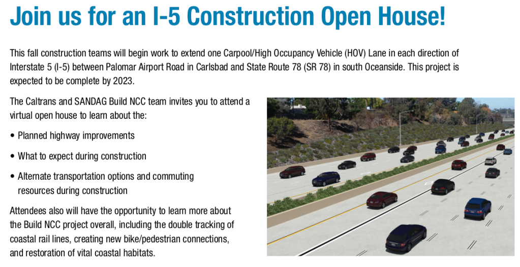
SANDAG and Caltrans are holding a virtual meeting Wednesday (Sept 22) from 6-8pm. The main topic is the plan to (between now and 2023) add express lanes on Interstate 5 between SR-78 and Palomar Airport Road. As on I-15, express lanes will be free for carpools (and certain “clean air” vehicles) but allow other drivers to pay to use the lane.
More generally, the session is about the broader North Coast Corridor project, partly funded by the 40-year renewal of the “TransNet” half-cent sales tax increase that runs through 2048. The $6 billion NCC project includes
Highway improvements from SR-52 to Camp Pendleton to add interchanges, express lanes and sound walls
$1 billion in rail improvements, including track construction for Coaster (south of Oceanside) and Metrolink (north of Oceanside), rail bridges, bluff stabilization and expansion of Coaster train stations
$200 million for environment preservation and beach access
Bicycle and pedestrian improvements near the freeway and on freeway overpasses
Here are several key opportunities to South O residents to participate in several key decisions regarding Buccaneer and several other key area of community:
8:30am July 31: next meeting of Save Oceanside Sand
By 6pm Aug. 6 (South O residents only): deadline for a one-question survey regarding the priorities for community reuse of NCTD land between Cassidy and Morse: either a beach trail or expanded parking.
Finally, on a lighter note, the 8th Annual South O Car/Boat/Bike Show is being held 9am-3pm Aug. 28 as a fundraiser for South O Elementary. To register or for more information, see http://socalcarculture.com/events.html
As in previous years, San Francisco (and now San Diego) legislators are proposing bad legislation to strip local cities of zoning control. There is limited time to block this legislation before it passes the Assembly and goes to the governor for his signature.
As before, these are gifts to developers (i.e. campaign contributors) rather than serious efforts to increase affordable housing. Two bills in particular seek to end single-family zoning as is the norm in most of Oceanside. Both bills are sponsored (18,800 residents/sq. mile) to places like Oceanside (4,250 residents/sq. mile) and Carlsbad (3,050 residents/sq. mile).
Neither bill conditions these density increases on building actual affordable housing. Previous Wiener-passed bills have allowed developers to increase revenues without lowering prices. As we have seen from recent projects proposed in Oceanside, the developers will use these incentives to maximize the density and minimize the parking provided by their projects —
The (intended) result of both bills is to reduce the supply of single-family housing — replacing them with apartments and condos — thus making single family homes unavailable to all but the most well-off of Californians. According to the AIDS Healthcare Foundation, taking home ownership away also eliminates a crucial path for building wealth and financial security for the average Californian.
Legislative Status
Both bills have passed the state Senate and now are in the state Assembly. Oceanside’s state senator, Pat Bates (R-Laguna Niguel), voted against both bills. However, she is facing term limits and will be replaced by a new state senator in the November 2022 election.
Oceanside’s assemblymember, Tasha Boerner Horvath (D-Encinitas) voted no on SB-10 in the Local Government committee but did not vote (either way) for SB-9. Her office contact information is as follows:
If that’s not bad enough, the Biden Administration has signaled its intention to create a national policy eliminating single-family housing as part of its “infrastructure” legislation. (It is dishonest to call this a federal bill, since taking away local zoning control on a nationwide basis is the antithesis of Federalism.)
The infrastructure legislation is currently under negotiation and has not been released for public reading. We will update you when when we learn more about how (or if) this policy is incorporated in the final legislation.
Save South O has been pushing for more than two years to have the city provide a holistic plan of the various projects plan around and near Buccaneer Park:
The Loma Alta Creek restoration project, including creation of a pedestrian trail on the north side of the creek
Upgrading the bathrooms/restaurant building that serves Buccaneer Beach and Park
Redevelopment of the unused 7 acres freed up by the planned closure of the La Salina Wastewater Treatment Plant
In particular, the city has (repeatedly) refused to commit to using all (or even some) of the WWTP land for parkland, even though both parkland (and parking for visitors to use the park) need to be expanded.
Representatives of Save South O met with Park & Rec staff, the city manager, and council members arguing that the city needs to develop a master plan before building anything at the site. The development of the site (like other projects) was slowed down due to COVID-19, allowing the planning process to catch up with the schedule for these various projects.
Update: The city has posted a survey about existing and future uses of the park. We encourage South O residents to push to expand Buccaneer Park using the land freed up by the closure of the WWTP.
The city has now committed to hold two public hearings about plans for the future of Buccaneer:
Workshop #1:
Date: Saturday, July 10th Time: 10am – 2pm Location: Buccaneer Park – 1506 S. Pacific Street, Oceanside, CA 92054
Workshop #2:
Date: Thursday, July 22nd Time: 9am-1pm Location: Main Street Farmer’s Market – Corner of Coast Highway and Pier View Way
We encourage South O residents to turn out en masse at these meetings to advocate both for expanding Buccaneer Park, and for a design that maximizes the availability for park land for use by South O and the community more generally.